Portal:World
The World Portal


The world is the totality of entities, the whole of reality, or everything that exists. The nature of the world has been conceptualized differently in different fields. Some conceptions see the world as unique, while others talk of a "plurality of worlds". Some treat the world as one simple object, while others analyze the world as a complex made up of parts.
In scientific cosmology, the world or universe is commonly defined as "the totality of all space and time; all that is, has been, and will be". Theories of modality talk of possible worlds as complete and consistent ways how things could have been. Phenomenology, starting from the horizon of co-given objects present in the periphery of every experience, defines the world as the biggest horizon, or the "horizon of all horizons". In philosophy of mind, the world is contrasted with the mind as that which is represented by the mind.
Theology conceptualizes the world in relation to God, for example, as God's creation, as identical to God, or as the two being interdependent. In religions, there is a tendency to downgrade the material or sensory world in favor of a spiritual world to be sought through religious practice. A comprehensive representation of the world and our place in it, as is found in religions, is known as a worldview. Cosmogony is the field that studies the origin or creation of the world, while eschatology refers to the science or doctrine of the last things or of the end of the world.
In various contexts, the term "world" takes a more restricted meaning associated, for example, with the Earth and all life on it, with humanity as a whole, or with an international or intercontinental scope. In this sense, world history refers to the history of humanity as a whole, and world politics is the discipline of political science studying issues that transcend nations and continents. Other examples include terms such as "world religion", "world language", "world government", "world war", "world population", "world economy", or "world championship". (Full article...)
Selected articles -
-
![Image 1 The United Nations Framework Convention on Climate Change (UNFCCC) is the UN process for negotiating an agreement to limit dangerous climate change. It is an international treaty among countries to combat "dangerous human interference with the climate system". The main way to do this is limiting the increase in greenhouse gases in the atmosphere. It was signed in 1992 by 154 states at the United Nations Conference on Environment and Development (UNCED), informally known as the Earth Summit, held in Rio de Janeiro. The treaty entered into force on 21 March 1994. "UNFCCC" is also the name of the Secretariat charged with supporting the operation of the convention, with offices on the UN Campus in Bonn, Germany. The convention's main objective is explained in Article 2. It is the "stabilization of greenhouse gas concentrations in the atmosphere at a level that would prevent dangerous anthropogenic [i.e., human-caused] interference with the climate system". The treaty calls for continuing scientific research into the climate. This research supports meetings and negotiations to lead to agreements. The aim is to allow ecosystems to adapt to climate change. At the same time it aims to ensure there are no threats to food production from climate change or measures to address it. And it aims to enable economic development to proceed in a sustainable manner. The UNFCCC's work currently focuses on implementing the Paris Agreement. This agreement entered into force in 2016. It aims to limit the rise in global temperature to well below 2 °C (3.6 °F) above levels before the Industrial Revolution, and even aiming to hold it at 1.5 °C (2.7 °F). The Paris Agreement superseded the UNFCCC's Kyoto Protocol which had been signed in 1997 and ran from 2005 to 2020. (Full article...)](//upload.wikimedia.org/wikipedia/en/d/d2/Blank.png)

The United Nations Framework Convention on Climate Change (UNFCCC) is the UN process for negotiating an agreement to limit dangerous climate change. It is an international treaty among countries to combat "dangerous human interference with the climate system". The main way to do this is limiting the increase in greenhouse gases in the atmosphere. It was signed in 1992 by 154 states at the United Nations Conference on Environment and Development (UNCED), informally known as the Earth Summit, held in Rio de Janeiro. The treaty entered into force on 21 March 1994. "UNFCCC" is also the name of the Secretariat charged with supporting the operation of the convention, with offices on the UN Campus in Bonn, Germany.
The convention's main objective is explained in Article 2. It is the "stabilization of greenhouse gas concentrations in the atmosphere at a level that would prevent dangerous anthropogenic [i.e., human-caused] interference with the climate system". The treaty calls for continuing scientific research into the climate. This research supports meetings and negotiations to lead to agreements. The aim is to allow ecosystems to adapt to climate change. At the same time it aims to ensure there are no threats to food production from climate change or measures to address it. And it aims to enable economic development to proceed in a sustainable manner. The UNFCCC's work currently focuses on implementing the Paris Agreement. This agreement entered into force in 2016. It aims to limit the rise in global temperature to well below 2 °C (3.6 °F) above levels before the Industrial Revolution, and even aiming to hold it at 1.5 °C (2.7 °F). The Paris Agreement superseded the UNFCCC's Kyoto Protocol which had been signed in 1997 and ran from 2005 to 2020. (Full article...) -

The map of the mouth of the River Amazon
The International Map of the World (IMW; also the Millionth Map of the World, after its scale of 1:1 000 000) was a project to create a complete map of the world according to internationally agreed standards. It was first proposed by the German geographer Albrecht Penck in 1891.
The Central Bureau of the Map of the World was established in London. After the Second World War, UNESCO took over the project. By 1953, 400 sheets had been produced. The completed sheets became outdated before the project had produced a full set of maps, and by the 1960s was being dismissed as being of no practical use. The project was no longer monitored by the 1990s. (Full article...) -
World Heritage Sites are landmarks and areas with legal protection under an international treaty administered by UNESCO for having cultural, historical, or scientific significance. The sites are judged to contain "cultural and natural heritage around the world considered to be of outstanding value to humanity".
To be selected, a World Heritage Site is nominated by its host country and determined by the UNESCO's World Heritage Committee to be a unique landmark which is geographically and historically identifiable, having a special cultural or physical significance, and to be under a sufficient system of legal protection. World Heritage Sites might be ancient ruins or historical structures, buildings, cities, deserts, forests, islands, lakes, monuments, mountains or wilderness areas, and others. (Full article...) -
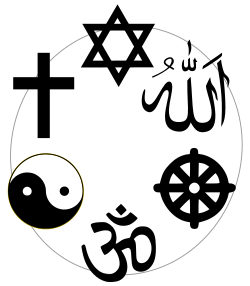
Symbols commonly associated with six of the religions labelled "world religions": clockwise from the top, these represent Judaism, Islam, Buddhism, Hinduism, Taoism, and Christianity.
World religions is a socially-constructed category used in the study of religion to demarcate religions that are deemed to have been especially large, internationally widespread, or influential in the development of human societies. It typically consists of the "Big Five" religions: Buddhism, Christianity, Hinduism, Islam, and Judaism. These are often juxtaposed against other categories, such as folk religions, Indigenous religions, and new religious movements (NRMs), which are also used by scholars in this field of research.
The "World Religions paradigm" was developed in the United Kingdom during the 1960s, where it was pioneered by phenomenological scholars of religion such as Ninian Smart. It was designed to broaden the study of religion away from its heavy focus on Christianity by taking into account other large religious traditions around the world. The paradigm is often used by lecturers instructing undergraduate students in the study of religion and is also the framework used by school teachers in the United Kingdom and other countries. The paradigm's emphasis on viewing these religious movements as distinct and mutually exclusive entities has also had a wider impact on the categorisation of religion—for instance in censuses—in both Western countries and elsewhere. (Full article...) -

World War I or the First World War (28 July 1914 – 11 November 1918), also known as the Great War, was a global conflict between two coalitions: the Allies (or Entente) and the Central Powers. Main areas of conflict included Europe and the Middle East, as well as parts of Africa and the Asia-Pacific. There were important developments in weaponry including tanks, aircraft, artillery, machine guns, and chemical weapons. One of the deadliest conflicts in history, it resulted in an estimated 30 million military casualties, plus another 8 million civilian deaths from war-related causes and genocide. The movement of large numbers of people was a major factor in the deadly Spanish flu pandemic.
The causes of World War I included the rise of Germany and decline of the Ottoman Empire, which disturbed the long-standing balance of power in Europe, imperial rivalries, and shifting alliances and an arms race between the great powers. Growing tensions between the great powers and in the Balkans reached a breaking point on 28 June 1914, when Gavrilo Princip, a Bosnian Serb, assassinated Franz Ferdinand, the heir to the Austro-Hungarian throne. Austria-Hungary blamed Serbia, and declared war on 28 July. After Russia mobilised in Serbia's defence, Germany declared war on Russia and France, who had an alliance. The United Kingdom entered after Germany invaded Belgium, and the Ottomans joined the Central Powers in November. Germany's strategy in 1914 was to quickly defeat France then transfer its forces to the east, but its advance was halted in September, and by the end of the year the Western Front consisted of a near-continuous line of trenches from the English Channel to Switzerland. The Eastern Front was more dynamic, but neither side gained a decisive advantage, despite costly offensives. Italy, Bulgaria, Romania, Greece and others entered the war from 1915 onward. (Full article...) -

Chart of the world's gross domestic product over the last two millennia
The global financial system is the worldwide framework of legal agreements, institutions, and both formal and informal economic action that together facilitate international flows of financial capital for purposes of investment and trade financing. Since emerging in the late 19th century during the first modern wave of economic globalization, its evolution is marked by the establishment of central banks, multilateral treaties, and intergovernmental organizations aimed at improving the transparency, regulation, and effectiveness of international markets. In the late 1800s, world migration and communication technology facilitated unprecedented growth in international trade and investment. At the onset of World War I, trade contracted as foreign exchange markets became paralyzed by money market illiquidity. Countries sought to defend against external shocks with protectionist policies and trade virtually halted by 1933, worsening the effects of the global Great Depression until a series of reciprocal trade agreements slowly reduced tariffs worldwide. Efforts to revamp the international monetary system after World War II improved exchange rate stability, fostering record growth in global finance.
A series of currency devaluations and oil crises in the 1970s led most countries to float their currencies. The world economy became increasingly financially integrated in the 1980s and 1990s due to capital account liberalization and financial deregulation. A series of financial crises in Europe, Asia, and Latin America followed with contagious effects due to greater exposure to volatile capital flows. The 2008 financial crisis, which originated in the United States, quickly propagated among other nations and is recognized as the catalyst for the worldwide Great Recession. A market adjustment to Greece's noncompliance with its monetary union in 2009 ignited a sovereign debt crisis among European nations known as the Eurozone crisis. The history of international finance shows a U-shaped pattern in international capital flows: high prior to 1914 and after 1989, but lower in between. The volatility of capital flows has been greater since the 1970s than in previous periods. (Full article...) -
World Englishes is a term for emerging localized or indigenized varieties of English, especially varieties that have developed in territories influenced by the United Kingdom or the United States. The study of World Englishes consists of identifying varieties of English used in diverse sociolinguistic contexts globally and analyzing how sociolinguistic histories, multicultural backgrounds and contexts of function influence the use of English in different regions of the world.
The issue of World Englishes was first raised in 1978 to examine concepts of regional Englishes globally. Pragmatic factors such as appropriateness, comprehensibility and interpretability justified the use of English as an international and intra-national language. In 1988, at a Teachers of English to Speakers of Other Languages (TESOL) conference in Honolulu, Hawaii, the International Committee of the Study of World Englishes (ICWE) was formed. In 1992, the ICWE formally launched the International Association for World Englishes (IAWE) at a conference of "World Englishes Today", at the University of Illinois, USA. There are two academic journals devoted to the study of this topic, titled English World-Wide (since 1980) and World Englishes (since 1982). There are a number of published handbooks and textbooks on the subject. (Full article...)
![Image 1 The United Nations Framework Convention on Climate Change (UNFCCC) is the UN process for negotiating an agreement to limit dangerous climate change. It is an international treaty among countries to combat "dangerous human interference with the climate system". The main way to do this is limiting the increase in greenhouse gases in the atmosphere. It was signed in 1992 by 154 states at the United Nations Conference on Environment and Development (UNCED), informally known as the Earth Summit, held in Rio de Janeiro. The treaty entered into force on 21 March 1994. "UNFCCC" is also the name of the Secretariat charged with supporting the operation of the convention, with offices on the UN Campus in Bonn, Germany. The convention's main objective is explained in Article 2. It is the "stabilization of greenhouse gas concentrations in the atmosphere at a level that would prevent dangerous anthropogenic [i.e., human-caused] interference with the climate system". The treaty calls for continuing scientific research into the climate. This research supports meetings and negotiations to lead to agreements. The aim is to allow ecosystems to adapt to climate change. At the same time it aims to ensure there are no threats to food production from climate change or measures to address it. And it aims to enable economic development to proceed in a sustainable manner. The UNFCCC's work currently focuses on implementing the Paris Agreement. This agreement entered into force in 2016. It aims to limit the rise in global temperature to well below 2 °C (3.6 °F) above levels before the Industrial Revolution, and even aiming to hold it at 1.5 °C (2.7 °F). The Paris Agreement superseded the UNFCCC's Kyoto Protocol which had been signed in 1997 and ran from 2005 to 2020. (Full article...)](/wiki/File:Blank.png)


General images -
-
 An artist's rendering of a protoplanetary disk (from History of Earth)
 -
 Tracy Caldwell Dyson, a NASA astronaut, observing Earth from the Cupola module at the International Space Station on 11 September 2010 (from Earth)
 -
 Artist's impression of the enormous collision that probably formed the Moon (from History of Earth)
 -
 Obelisk of Axum, Ethiopia
 -

-

-
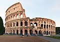 The Colosseum in Rome (from Human history)
 -
 Empires of the world in 1898
 -
 Artist's rendition of an oxinated fully-frozen Snowball Earth with no remaining liquid surface water. (from History of Earth)
 -
 Battle during the 1281 Mongol invasion of Japan
 -
 An impression of the Archean, the eon after Earth's formation, featuring round stromatolites, which are early oxygen-producing forms of life from billions of years ago. After the Late Heavy Bombardment, Earth's crust had cooled, its water-rich barren surface is marked by continents and volcanoes, with the Moon still orbiting Earth half as far as it is today, appearing 2.8 times larger and producing strong tides. (from Earth)
 -
-
 A map of heat flow from Earth's interior to the surface of Earth's crust, mostly along the oceanic ridges (from Earth)
 -
 Angkor Wat temple complex, Cambodia, early 12th century
 -
Artist's impression of Earth during the later Archean, the largely cooled planetary crust and water-rich barren surface, marked by volcanoes and continents, features already round microbialites. The Moon, still orbiting Earth much closer than today and still dominating Earth's sky, produced strong tides. (from History of Earth)
-
 Earth's history with time-spans of the eons to scale. Ma means "million years ago". (from History of Earth)
 -

-

-
 Image of the physical world, captured by the Hubble Space Telescope (from World)
 -
 Cross-section through a liposome (from History of Earth)
 -
 Pillar erected by Ashoka, a Mauryan Emperor in India
 -
 A schematic view of Earth's magnetosphere with solar wind flowing from left to right (from Earth)
 -
 Portrait of Alfraganus in the Compilatio astronomica, 1493. Islamic astronomers began just before the 9th century to collect and translate Indian, Persian and Greek astronomical texts, adding their own astronomy and enabling later, particularly European astronomy to build on. Symbolic for the post-classical period, a period of an increasing trans-regional literary culture, particularly in the sciences, spreading and building on methods of science. (from Human history)
 -
 Geologic map of North America, color-coded by age. From most recent to oldest, age is indicated by yellow, green, blue, and red. The reds and pinks indicate rock from the Archean.
 -
 Fall of the Berlin Wall, 1989
 -
 Earth's land use for human agriculture in 2019 (from Earth)
 -
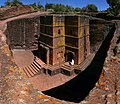 One of the eleven Rock-hewn Churches of Lalibela constructed during the Zagwe dynasty in Ethiopia (from Human history)
 -
 Taj Mahal, Mughal Empire, India
 -
 Earth's night-side upper atmosphere appearing from the bottom as bands of afterglow illuminating the troposphere in orange with silhouettes of clouds, and the stratosphere in white and blue. Next the mesosphere (pink area) extends to the orange and faintly green line of the lowest airglow, at about one hundred kilometers at the edge of space and the lower edge of the thermosphere (invisible). Continuing with green and red bands of aurorae stretching over several hundred kilometers. (from Earth)
 -
 Olmec colossal head, now at the Museo de Antropología de Xalapa
 -
 Graph showing range of estimated partial pressure of atmospheric oxygen through geologic time (from History of Earth)
 -
 Florence, birthplace of the Italian Renaissance
 -
 Notre-Dame de Paris, France
 -
 Pale orange dot, an impression of Early Earth, featuring its tinted orange methane-rich early atmosphere (from Earth)
 -
 An animation of the changing density of productive vegetation on land (low in brown; heavy in dark green) and phytoplankton at the ocean surface (low in purple; high in yellow) (from Earth)
 -

-

-
 A reconstruction of human history based on fossil data. (from History of Earth)
 -
 Pangaea was a supercontinent that existed from about 300 to 180 Ma. The outlines of the modern continents and other landmasses are indicated on this map. (from History of Earth)
 -
 Artist's conception of Hadean Eon Earth, when it was much hotter and inhospitable to all forms of life. (from History of Earth)
 -

-
 Last Moon landing: Apollo 17 (1972)
 -
 A view of Earth with different layers of its atmosphere visible: the troposphere with its clouds casting shadows, a band of stratospheric blue sky at the horizon, and a line of green airglow of the lower thermosphere around an altitude of 100 km, at the edge of space (from Earth)
 -
 Carving of Persian and Median soldiers, Persepolis, Achaemenid Empire, 5th century BCE
 -
 The first airplane, the Wright Flyer, flew on 17 December 1903.
 -
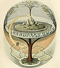 Yggdrasil, an attempt to reconstruct the Norse world tree which connects the heavens, the world, and the underworld. (from World)
 -
 Great Pyramids of Giza, Egypt
 -

-
 Successive dispersals of Homo erectus (yellow), Homo neanderthalensis (ochre) during Out of Africa I and Homo sapiens (red, Out of Africa II), with the numbers of years since they appeared before present. (from Human history)
 -
 Chennakesava Temple, Belur, India
 -
 European migrations by mostly Germanic peoples, 2nd–6th centuries (from Human history)
 -
 Tiktaalik, a fish with limb-like fins and a predecessor of tetrapods. Reconstruction from fossils about 375 million years old. (from History of Earth)
 -
 A composite image of Earth, with its different types of surface discernible: Earth's surface dominating Ocean (blue), Africa with lush (green) to dry (brown) land and Earth's polar ice in the form of Antarctic sea ice (grey) covering the Antarctic or Southern Ocean and the Antarctic ice sheet (white) covering Antarctica. (from Earth)
 -
 A banded iron formation from the 3.15 Ga Moodies Group, Barberton Greenstone Belt, South Africa. Red layers represent the times when oxygen was available; gray layers were formed in anoxic circumstances. (from History of Earth)
 -
 Satellite time lapse imagery of Earth's rotation showing axis tilt (from Earth)
 -
 13th-century French historiated initial with the three classes of medieval society: those who prayed (the clergy), those who fought (the knights), and those who worked (the peasantry)
 -
 Lithified stromatolites on the shores of Lake Thetis, Western Australia. Archean stromatolites are the first direct fossil traces of life on Earth. (from History of Earth)
 -
 A view of Earth with its global ocean and cloud cover, which dominate Earth's surface and hydrosphere; at Earth's polar regions, its hydrosphere forms larger areas of ice cover. (from Earth)
 -
-
 Cuneiform inscription, eastern Turkey
 -
The pale orange dot, an artist's impression of the early Earth which might have appeared orange through its hazy methane rich prebiotic second atmosphere. Earth's atmosphere at this stage was somewhat comparable to today's atmosphere of Titan. (from History of Earth)
-
 A 580 million year old fossil of Spriggina floundensi, an animal from the Ediacaran period. Such life forms could have been ancestors to the many new forms that originated in the Cambrian Explosion. (from History of Earth)
 -
 Ming dynasty section, Great Wall of China
 -

-
 Dinosaurs were the dominant terrestrial vertebrates throughout most of the Mesozoic (from History of Earth)
 -
 Artist's impression of a Hadean landscape with the relatively newly formed Moon still looming closely over Earth and both bodies sustaining strong volcanism. (from History of Earth)
 -
 Japanese depiction of a Portuguese carrack, a result of globalizing maritime trade
 -
 A computer-generated image mapping the prevalence of artificial satellites and space debris around Earth in geosynchronous and low Earth orbit (from Earth)
 -
 A composite image of artificial light emissions at night on a map of Earth (from Earth)
 -
 The replicator in virtually all known life is deoxyribonucleic acid. DNA is far more complex than the original replicator and its replication systems are highly elaborate. (from History of Earth)
 -
 Trilobites first appeared during the Cambrian period and were among the most widespread and diverse groups of Paleozoic organisms. (from History of Earth)
 -
 Artist's conception of Devonian flora (from History of Earth)
 -
 Change in average surface air temperature and drivers for that change. Human activity has caused increased temperatures, with natural forces adding some variability. (from Earth)
 -
 Machu Picchu, Inca Empire, Peru
 -
 Earth's axial tilt causing different angles of seasonal illumination at different orbital positions around the Sun (from Earth)
 -
-
 Chloroplasts in the cells of a moss (from History of Earth)
 -
 Shanghai. China urbanized rapidly in the 21st century.
 -
 Standing Buddha from Gandhara, 2nd century CE
 -
 Earth's western hemisphere showing topography relative to Earth's center instead of to mean sea level, as in common topographic maps (from Earth)
 -
 Vitruvian Man, c. 1490 by Leonardo da Vinci, epitomizes the advances in art and science seen during the Renaissance. (from History of Earth)
 -
 A depiction of the early Solar System's protoplanetary disk from which Earth and other Solar System bodies were formed (from Earth)
 -
 A reconstruction of Pannotia (550 Ma). (from History of Earth)
 -
 An artist's impression of ice age Earth at glacial maximum. (from History of Earth)
 -
 Benin Bronze head from Nigeria
 -
 A pillar at Neolithic Göbekli Tepe
 -
 COVID-19 pandemic, 2020 (from Human history)


.svg)


.jpg)


.png)


.jpeg)

.jpg)


Megacities of the world -

Hyderabad is the capital and largest city of the Indian state of Telangana. It occupies 650 km2 (250 sq mi) on the Deccan Plateau along the banks of the Musi River, in the northern part of Southern India. With an average altitude of 536 m (1,759 ft), much of Hyderabad is situated on hilly terrain around artificial lakes, including the Hussain Sagar lake, predating the city's founding, in the north of the city centre. According to the 2011 census of India, Hyderabad is the fourth-most populous city in India with a population of 6.9 million residents within the city limits, and has a population of 9.7 million residents in the metropolitan region, making it the sixth-most populous metropolitan area in India.
The Qutb Shahi dynasty's Muhammad Quli Qutb Shah established Hyderabad in 1591 to extend the capital beyond the fortified Golconda. In 1687, the city was annexed by the Mughals. In 1724, Asaf Jah I, the Mughal viceroy, declared his sovereignty and founded the Asaf Jahi dynasty, also known as the Nizams. Hyderabad served as the imperial capital of the Asaf Jahis from 1769 to 1948. As the capital of the princely state of Hyderabad, the city housed the British Residency and cantonment until Indian independence in 1947. Hyderabad was annexed by the Indian Union in 1948 and continued as a capital of Hyderabad State from 1948 to 1956. After the introduction of the States Reorganisation Act of 1956, Hyderabad was made the capital of the newly formed Andhra Pradesh. In 2014, Andhra Pradesh was split to form the state of Telangana, and Hyderabad became the joint capital of the two states until 2024. Since 1956, the city has housed the Rashtrapati Nilayam, the winter office of the president of India. (Full article...)
Did you know -

- ... that the choreography of "How You Get the Girl" during the 1989 World Tour resembled that of the musical Singin' in the Rain?
- ... that Karl Braun and other German scientists played cards with their British colleagues during World War I?
- ... that at the 1965 World Pentathlon Championships, Herbert Polzhuber was said to have drunk ten beers and a bottle of cognac before firing his pistol at the ground and passing out?
- ... that a million tulips at the 1939 New York World's Fair were destroyed and replaced the month after the fair began?
- ... that in 2023 the IFLA named the Biblioteca Gabriel García Márquez the "best new public library in the world"?
- ... that William J. Murphy's presidency of Boston College began 16 days before the start of World War II and concluded five days after hostilities ended?
- ... that "the world's ugliest woman" won the women's world gurning title 28 times?
- ... that Indonesian radio presenters Muhammad Farhan and Indy Barends co-hosted a 32-hour nonstop radio show in 2001, setting a national record which they held until 2019?
Countries of the world -

Monaco, officially the Principality of Monaco, is a sovereign city-state and microstate in Western Europe. Situated on the French Riviera, it is a semi-enclave bordered by France to the north, east, and west, with the Mediterranean Sea to the south; the Italian region of Liguria is about 15 km (9.3 mi) east. With a population of 38,423 living in an area of 2.08 km2 (0.80 sq mi), Monaco is the second smallest sovereign state in the world, after Vatican City, as well as the most densely populated. It also has the world's shortest national coastline of any non-landlocked nation, at 3.83 km (2.38 mi). Fewer than 10,000 of its residents are Monégasque nationals. While the official language of Monaco is French, Italian and Monégasque are also widely spoken and understood.
Monaco is governed under a form of semi-constitutional monarchy, with Prince Albert II as head of state, who holds substantial political powers. The prime minister, who is the head of government, can be either a Monégasque or French citizen; the monarch consults with the Government of France before an appointment. Key members of the judiciary are detached French magistrates. The House of Grimaldi has ruled Monaco, with brief interruptions, since 1297. The state's sovereignty was officially recognised by the Franco-Monégasque Treaty of 1861, with Monaco becoming a full United Nations voting member in 1993. Despite Monaco's independence and separate foreign policy, its defence is the responsibility of France, notwithstanding two small military units. (Full article...)
Seven Wonders of the Industrial World is a 7-part British docudrama television miniseries that originally aired from 4 September 2003 to 16 October 2003 on BBC and was later released on DVD. The programme examines seven engineering feats that occurred since the Industrial Revolution. The same feats are covered in a companion book of the same name by producer Deborah Cadbury. (Full article...)
Related portals
Protected areas of the world -
-

Mombacho Volcano Natural Reserve
The protected areas of Nicaragua are areas that have natural beauty or significance and are protected by Nicaragua. Nicaragua has 78 protected areas that cover 22,422 km2, about 17.3% of the nations landmass. The National System of Protected Areas (SINAP) is administered by the Ministry of the Environment and Natural Resources (MARENA). (Full article...) -

Part of the Brecon Beacons National Park, looking from the highest point of Pen y Fan (886 m/2907 feet) to Cribyn (795 m/2608 feet).
Protected areas of the United Kingdom are areas in the United Kingdom which need and /or receive protection because of their environmental, historical or cultural value to the nation. Methods and aims of protection vary depending on the nature and importance of the resource. Protection operates at local, regional, national and international levels, and may be backed by legislation and international treaty, or less formally by planning policy.
Within the United Kingdom, different approaches are taken to some forms of protection within the constituent countries of England, Scotland, Wales and Northern Ireland, while other forms of protection are more consistent across the UK. Protected areas can be divided according to the type of resource which each seeks to protect. Primarily, these are: scenic or landscape value; biodiversity value (species and habitats); geodiversity value (relating to geology and geomorphology); and cultural or historic value. Several types of protected areas are focused on more than one of these areas. (Full article...) -
Bihar is a state in East India. It is bounded by Uttar Pradesh to the west, Nepal to the north, West Bengal to the east and Jharkhand to the south. About 7% of the state is protected forest area. (Full article...)
-

The sun over the Lake Niassa Reserve
Protected areas in Mozambique are known as conservation areas, and are currently grouped into national parks, national reserves, forest reserves, wildlife utilisation areas (coutadas), community conservation areas, and private game farms (fazendas de bravio). There are also a number of areas that have been declared as protected areas under a variety of different legislation, which for reasons of simplicity are here grouped together as "other protected areas." Under the Conservation Law of 2014 (Law 16/2014 of June 20), protected areas will need to be reclassified into a much more flexible series of new categories which are closer to the international system used by the IUCN. International initiatives such as transfrontier parks are grouped at the end of the page. (Full article...) -
The Protected areas of Kyrgyzstan are regulated by the law on specially protected natural areas of 2 May 2011, last modified on 2 June 2018. In total, they cover 14,761.216 km2 (5,699.337 sq mi) and account for 7.38% of the country's total area (as of 2017). The first protected area in Kyrgyzstan (Issyk-Kul) was established in 1948. According to the Government Decree on Priorities of Conservation of Biological Diversity and the relevant Action Plan for 2014-2024 the target area for the protected areas in Kyrgyzstan is 10 percent of the country’s area by 2024.
The protected areas are subdivided into seven categories: (Full article...) -
Protected areas of Tamil Nadu cover an area of 3,305 km2 (1,276 sq mi), constituting 2.54% of the geographic area and 15% of the 22,643 km2 (8,743 sq mi) recorded forest area of the state of Tamil Nadu in South India. It ranks 14th among all the states and union territories of India in terms of total protected area.
Protected areas in South India were created from private hunting grounds of the erstwhile Maharajas of the princely states. Mudumalai National Park was established in 1940 and was the first modern wildlife sanctuary in South India. The protected areas are administered by the Ministry of Environment and Forests of Government of India and the Tamil Nadu Forest Department. (Full article...) -
China has more than 10,000 protected areas, covering eighteen percent of the country's land. There are many forms of protected areas in China. Based on their relative importance, each type of protected area can be further graded into two to three levels (national, provincial and prefectural/county level). Nevertheless, the highest rank for "pocket nature preserve" (social and mass-based), "no-hunting area", "no-fishing area", "no-logging area", "wild medicinal material resources conservation area", "crop germplasm resources conservation area", "forest tree germplasm resources conservation area" or "source water protection area" is practically restricted to provincial level. The local government at county level is also responsible for the delimitation and declaration of "basic farmland protection area" and "basic grassland".
Take note that many protected areas in China have multiple official designations, and the statutory boundaries of these multi-designated PAs may be identical or may vary one from the other. For instance, the boundaries of Huangshan NSHA coincide with those of the Huangshan NGP, whereas Fujian province's Wuyi Mountains NNR, NSHA and NFP are adjacent to each other. In Heilongjiang, 27,642.14 hectares out of 115,340.27 hectares of Huzhong NFP are intersected with the experiment zone of Huzhong NNR. (Full article...) -
This is a list of protected areas of Sierra Leone, including national parks, game reserves, conservation areas, wetlands, and those that are listed as proposed protected areas in the UN Environment Programme World Conservation Monitoring Centre (UNEP WCM) database. (Full article...)
-
Greece is characterized by an extremely fragmented, rugged landscape hosting a great diversity of ecosystems and an outstanding biodiversity. Almost 5% of its extensive coastline consists of ecologically sensitive wetlands. Two thirds of the total population live no further than 2 km from the coast and most of the important urban centers are coastal, while almost all of the tourist infrastructure is divided among islands and the coastal mainland. (Full article...)
-
Protected areas of Australia include Commonwealth and off-shore protected areas managed by the Australian government, as well as protected areas within each of the six states of Australia and two self-governing territories, the Australian Capital Territory and the Northern Territory, which are managed by the eight state and territory governments.
Commonwealth and off-shore protected areas in the Australian Capital Territory, the Northern Territory, the Christmas Island Territory, the Cocos (Keeling) Islands Territory, the Norfolk Island Territory and the Australian Antarctic Territory are managed by Director of National Parks, an agency within the Department of Climate Change, Energy, the Environment and Water, with the exception of the Great Barrier Reef Marine Park, which is managed by the Great Barrier Reef Marine Park Authority, a separate body within the department. (Full article...) -

Centre for Nature Education at the Białowieża National Park, Poland
Protected areas of Poland include the following categories, as defined by the Act on Protection of Nature (Polish: Ustawa o ochronie przyrody) of 16 April 2004, by the Polish Parliament: (Full article...) -

A view of Kaptai National Park
This is a list of protected areas of Bangladesh. Bangladesh is a country in South Asia. There are 53 Protected Areas contains about 818247.46 hectares (Terrestrial & Marine). Out of this, Terrestrial Protectet Areas contains 470147.46 hectares which represents 3.19% area of the country. Protected areas include:- 19 National Parks
- 25 Wildlife Sanctuaries
- 2 Special Biodiversity Conservation Areas
- 2 Marine Protected Areas
- 2 Vulture Safe Zones
- 2 Botanical Gardens
- 2 Safari Parks
- 10 Eco Parks
- 1 Aviary Park
-
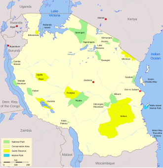
Protected areas in Tanzania (Hifadhi za Mali hai za Tanzania, in Swahili) are extremely varied, ranging from sea habitats over grasslands to the top of the Kilimanjaro, the tallest mountain in Africa. About a third of the country's total area is protected to a certain degree as a national park, game reserve, marine park, forest reserve or the like. 840 protected areas are spread across 7,330 km² of ocean and 361,594 km² of land in Tanzania. The coastal and marine areas are less protected than terrestrial ecosystems, which are given the highest level of protection. Tanzania is one of the world's major biodiversity hotspots thanks to its vast national parks, "the Eastern Arc" mountains, wetlands, coastal forests, marine, and freshwater systems as remarkable reservoirs of plant and animal species. A wide range of endemic species of birds, reptiles, snakes, amphibians, wild coffee variations, and the well-known African violet flower can also be found in Tanzania. (Full article...) -

The Valley of the Giants skywalk at Walpole-Nornalup National Park
Western Australia is the second largest country subdivision in the world.
As of 2022, based on the latest Collaborative Australian Protected Areas Database report, it contains 1857 separate land-based protected areas with a total area of 76,142,710 hectares (188,152,700 acres), accounting for just over 30 percent of the state's land mass. By area, Indigenous Protected Areas account for the largest part of this, almost 67 percent while, by number, nature reserves hold the majority with two-third of all land-based protected areas being nature reserves. (Full article...) -

The protected areas of Bhutan are its national parks, nature preserves, and wildlife sanctuaries. Most of these protected areas were first set aside in the 1960s, originally covering most of the northern and southern regions of Bhutan. Today, protected areas cover more than 42% of the kingdom, mostly in the northern regions. Protected areas also line most of Bhutan's international borders with China and India. (Full article...)

.jpg)


Selected world maps
-
 Index map from the International Map of the World (1:1,000,000 scale)
 -
 1516 map of the world by Martin Waldseemüller
 -
 The Goode homolosine projection is a pseudocylindrical, equal-area, composite map projection used for world maps.
 -
 Only a few of the largest large igneous provinces appear (coloured dark purple) on this geological map, which depicts crustal geologic provinces as seen in seismic refraction data
 -
 Time zones of the world
 -
 United Nations Human Development Index map by country (2016)
 -
 The world map by Gerardus Mercator (1569), the first map in the well-known Mercator projection
 -
 A plate tectonics map with volcano locations indicated with red circles
 -
 Mollweide projection of the world


World records
- List of Olympic records in athletics
- List of world records in athletics
- List of junior world records in athletics
- List of world records in masters athletics
- List of world youth bests in athletics
- List of IPC world records in athletics
- List of world records in canoeing
- List of world records in chess
- List of cycling records
- List of world records in track cycling
- List of world records in finswimming
- List of world records in juggling
- List of world records in rowing
- List of world records in speed skating
- List of world records in swimming
- List of IPC world records in swimming
- List of world records in Olympic weightlifting
Topics

Continents of Earth | ||||||||
|---|---|---|---|---|---|---|---|---|
| ||||||||
| ||||||||
| ||||||||


| Cenozoic Era (present–66.0 Ma) |
| ||||||||||||
|---|---|---|---|---|---|---|---|---|---|---|---|---|---|
| Mesozoic Era (66.0–252 Ma) |
| ||||||||||||
| Paleozoic Era (252–539 Ma) |
| ||||||||||||
| Proterozoic Eon (539 Ma–2.5 Ga) |
| ||||||||||||
| Archean Eon (2.5–4 Ga) | |||||||||||||
| Hadean Eon (4–4.6 Ga) | |||||||||||||
ka = kiloannum (thousand years ago); Ma = megaannum (million years ago); Ga = gigaannum (billion years ago). See also: Geologic time scale • | |||||||||||||
| Locations | ||
|---|---|---|
| Related | ||

| |||||||||||||||||||
| |||||||||||||||||||
| |||||||||||||||||||
Economic classification of countries | |||||
|---|---|---|---|---|---|
| Three-World Model | |||||
| Gross domestic product (GDP) |
| ||||
| Gross national income (GNI) | |||||
| Wages | |||||
| Wealth | |||||
| Other national accounts | |||||
| Human development | |||||
| Digital divide | |||||
| Net international investment position (NIIP) | |||||
| Technological |
| ||||
|---|---|---|---|---|---|
| Sociological | |||||
| Ecological |
| ||||
| Biological |
| ||||
| Astronomical | |||||
| Eschatological |
| ||||
| Others |
| ||||
| Fictional | |||||
| Organizations | |||||
Categories

Wikimedia
The following Wikimedia Foundation sister projects provide more on this subject:
-
 Commons
Free media repository -
 Wikibooks
Free textbooks and manuals -
 Wikidata
Free knowledge base -
 Wikinews
Free-content news -
 Wikiquote
Collection of quotations -
 Wikisource
Free-content library -
 Wikispecies
Directory of species -
 Wikiversity
Free learning tools -
 Wikivoyage
Free travel guide -
 Wiktionary
Dictionary and thesaurus


