Libourne
Libourne | |
|---|---|
Subprefecture and commune | |
 Bridge over the Dordogne river | |
.svg) Coat of arms | |
Location of Libourne  | |
 Libourne  Libourne | |
| Coordinates: 44°55′N 0°14′W / 44.92°N 0.24°W | |
| Country | France |
| Region | Nouvelle-Aquitaine |
| Department | Gironde |
| Arrondissement | Libourne |
| Canton | Le Libournais-Fronsadais |
| Intercommunality | CA Libournais |
| Government | |
| • Mayor (2020–2026) | Philippe Buisson[1] (PS) |
Area 1 | 20.63 km2 (7.97 sq mi) |
| Population (2022)[2] | 24,668 |
| • Density | 1,196/km2 (3,097/sq mi) |
| Time zone | UTC+01:00 (CET) |
| • Summer (DST) | UTC+02:00 (CEST) |
| INSEE/Postal code | 33243 /33500 |
| Elevation | 2–28 m (6.6–91.9 ft) (avg. 15 m or 49 ft) |
| 1 French Land Register data, which excludes lakes, ponds, glaciers > 1 km2 (0.386 sq mi or 247 acres) and river estuaries. | |
Libourne (French pronunciation: [libuʁn] ⓘ; Gascon: Liborna [liˈbuɾnɔ]) is a commune in the Gironde department in Nouvelle-Aquitaine in southwestern France. It is a sub-prefecture of the department.
It is the wine-making capital of northern Gironde and lies near Saint-Émilion and Pomerol.
History
[edit]Like other sites at the confluence of important rivers, that of Libourne was appropriated at an early period. Under the Romans a colonia stood rather more than a mile to the south of the present Libourne; it was destroyed during the troubles of the 5th century. Resuscitated by Charlemagne, it was rebuilt in 1269, as Leybornia, and was founded as a bastide by Roger de Leybourne (of Leybourne, Kent), an English seneschal of Gascony, under the authority of King Edward I of England. It suffered considerably in the struggles of the French and English for the possession of Gironde in the Hundred Years' War,[3] and joined France in the 15th century.

In 1787 the parlement of Bordeaux was exiled to Libourne amid political crises.[4]
In December 1854 John Stuart Mill passed through Libourne, remarking "I stopped at Libourne as I intended & had a walk about it this morning quite the best thing there is the bridge of the Dordogne, the view from which is really fine".[5]
Sights
[edit]The Gothic church, restored in the 19th century, has a stone spire 71 m (232 ft) high. On the quay there is a machicolated clock-tower which is a survival of the defensive walls of the 14th century. The town-house, containing a small museum and a library, is a quaint relic of the 16th century.[3] It is located by the main square, the Place Abel Surchamp, which hosts every weekend one of the largest fresh food market in the region.[citation needed] There is a statue of Élie, duc Decazes, who was born in the region.[3]
Geography
[edit]Libourne is located at the confluence of the Isle and Dordogne rivers. Libourne station has rail connections to Bordeaux, Bergerac, Angoulême, Périgueux, Limoges, Brive-la-Gaillarde and Sarlat-la-Canéda.
| Climate data for Libourne (Saint-Émilion) (1995–2020 normals, extremes 1995–present) | |||||||||||||
|---|---|---|---|---|---|---|---|---|---|---|---|---|---|
| Month | Jan | Feb | Mar | Apr | May | Jun | Jul | Aug | Sep | Oct | Nov | Dec | Year |
| Record high °C (°F) | 18.6 (65.5) |
24.7 (76.5) |
26.3 (79.3) |
30.8 (87.4) |
35.5 (95.9) |
39.7 (103.5) |
40.9 (105.6) |
41.3 (106.3) |
37.9 (100.2) |
33.0 (91.4) |
25.2 (77.4) |
19.7 (67.5) |
41.3 (106.3) |
| Mean daily maximum °C (°F) | 9.9 (49.8) |
11.6 (52.9) |
15.4 (59.7) |
18.6 (65.5) |
22.2 (72.0) |
25.9 (78.6) |
27.8 (82.0) |
28.0 (82.4) |
24.7 (76.5) |
20.1 (68.2) |
13.8 (56.8) |
10.5 (50.9) |
19.0 (66.2) |
| Daily mean °C (°F) | 6.6 (43.9) |
7.3 (45.1) |
10.3 (50.5) |
13.1 (55.6) |
16.6 (61.9) |
19.8 (67.6) |
21.5 (70.7) |
21.5 (70.7) |
18.2 (64.8) |
14.9 (58.8) |
9.8 (49.6) |
7.1 (44.8) |
13.9 (57.0) |
| Mean daily minimum °C (°F) | 3.3 (37.9) |
3.1 (37.6) |
5.2 (41.4) |
7.6 (45.7) |
11.0 (51.8) |
13.8 (56.8) |
15.1 (59.2) |
14.9 (58.8) |
11.8 (53.2) |
9.6 (49.3) |
5.8 (42.4) |
3.6 (38.5) |
8.7 (47.7) |
| Record low °C (°F) | −8.3 (17.1) |
−12.0 (10.4) |
−9.0 (15.8) |
−1.8 (28.8) |
2.2 (36.0) |
5.6 (42.1) |
7.1 (44.8) |
6.2 (43.2) |
2.9 (37.2) |
−5.6 (21.9) |
−8.0 (17.6) |
−9.7 (14.5) |
−12.0 (10.4) |
| Average precipitation mm (inches) | 78.2 (3.08) |
61.5 (2.42) |
58.0 (2.28) |
72.4 (2.85) |
68.1 (2.68) |
58.2 (2.29) |
47.7 (1.88) |
55.2 (2.17) |
62.0 (2.44) |
61.4 (2.42) |
91.4 (3.60) |
84.0 (3.31) |
798.1 (31.42) |
| Average precipitation days (≥ 1.0 mm) | 12.5 | 10.4 | 10.6 | 11.2 | 9.9 | 8.0 | 7.3 | 7.7 | 8.1 | 9.8 | 13.2 | 12.5 | 121.3 |
| Source: Meteociel[6] | |||||||||||||
Population
[edit]
|
| ||||||||||||||||||||||||||||||||||||||||||||||||||||||||||||||||||||||||||||||||||||||||||||||||||||||||||||||||||
| |||||||||||||||||||||||||||||||||||||||||||||||||||||||||||||||||||||||||||||||||||||||||||||||||||||||||||||||||||
| Source: EHESS[7] and INSEE (1968-2017)[8] | |||||||||||||||||||||||||||||||||||||||||||||||||||||||||||||||||||||||||||||||||||||||||||||||||||||||||||||||||||
Gallery
[edit]-
 Town hall
 -
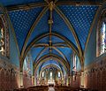 Nave of the Chapelle de Condat
 -
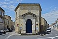
 Gate of the Port
 -
 Protestant temple


Notable people
[edit]- Eugène Atget (1857–1927), French photographer, "Creator and Purveyor of a Collection of Photographic Views of Old France"
- Georges Charles Marius Engerrand (1877–1961), geologist and archaeologist
- Florian Latorre (born 1997), racing driver
- Louis Le Provost de Launay (1850–1912), French deputy and senator
- Jean-Marie Londeix (1932–2025), French saxophonist
- Jean Marcadé (1920–2012), French Hellenist and historian
- Jean-Marie Poumeyrol (born 1946), artist
See also
[edit]- Hull town walls, the town of Hull, also established under Edward I, is said to have been similar in design to the Bastides, in particular Libourne
- Communes of the Gironde department
- Keynsham, twinned with Libourne
References
[edit]- ^ "Répertoire national des élus: les maires". data.gouv.fr, Plateforme ouverte des données publiques françaises (in French). 2 December 2020.
- ^ "Populations de référence 2022" (in French). The National Institute of Statistics and Economic Studies. 19 December 2024.
- ^ a b c One or more of the preceding sentences incorporates text from a publication now in the public domain: Chisholm, Hugh, ed. (1911). "Libourne". Encyclopædia Britannica. Vol. 16 (11th ed.). Cambridge University Press. p. 545.
- ^ Doyle, William (2018). The Oxford History of the French Revolution (3rd ed.). Oxford: Oxford University Press. p. 77. ISBN 9780198804932.
- ^ The Collected Works of John Stuart Mill Vol XIV, Page 251. ISBN 0-8020-5261-4
- ^ "Normales et records pour Saint-Émilion (33)". Meteociel. Retrieved 22 November 2024.
- ^ Des villages de Cassini aux communes d'aujourd'hui: Commune data sheet Libourne, EHESS (in French).
- ^ Population en historique depuis 1968, INSEE
External links
[edit]- Official website (in French)
- Unofficial website (in French)
| International | |
|---|---|
| National | |
| Geographic | |
| Other | |