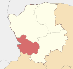
Volodymyr Raion
Volodymyr Raion
Володимирський район | |
|---|---|
 | |
| Coordinates: 50°51′00″N 24°12′00″E / 50.85000°N 24.20000°E | |
| Country | |
| Oblast | |
| Established | 1940 |
| Admin. center | Volodymyr |
| Subdivisions | 11 hromadas |
| Area | |
• Total | 2,558.2 km2 (987.7 sq mi) |
| Population (2022) | |
• Total | 169,231 |
| • Density | 66/km2 (170/sq mi) |
| Time zone | UTC+02:00 (EET) |
| • Summer (DST) | UTC+03:00 (EEST) |
| Area code | 380-3342 |
| Website | Volodymyrskyi Raion |
Volodymyr Raion (Ukrainian: Володимирський район) is a raion (district) in Volyn Oblast in western Ukraine. Its administrative center is the city of Volodymyr. Population: 169, 231. (2022) [2]
On 18 July 2020, as part of the administrative reform of Ukraine, the number of raions of Volyn Oblast was reduced to four, and the area of Volodymyr-Volynskyi Raion was significantly expanded. [3] The January 2020 estimate of the raion population was 24,545 (2020). On 18 July 2022 raion was renamed to Volodymyr Raion.[4]
Geography
[edit]
The area of the district is 2556.5 km2.[2]
The district borders the Lutsk Raion and Kovelskyi Raion of the Volyn Oblast, as well as the Lviv Oblast of Ukraine and the Poland .[5] The larger area of the district is located in the Volhynian Upland . The area of the area is located in the area of mixed forests and the river basin Luha (tributary of the Bug). The climate is moderately continental with mild winters (in January -4.4 °, -5.1 °) and warm wet summer (in July +18.8 °). Rainfall 550-640 mm per year.[6][7]
Communities of the district
[edit]Number of settlements 201. Number of cities – 3. The district includes 11 territorial communities. Urban communities are formed around the cities of Ustyluh, Volodymyr, Novovolynsk. 8 rural communities with centers in the Ivanychi village, Lokachi village, Zymne village, Ovadne village, Lytovezh village, Pavlivka village, Poromiv village, Zaturtsi village.[2]
Economy of the district
[edit]The area of agricultural land in the district is 55.67 thousand hectares. Crop production accounts for 97% of the agricultural production structure. [8]The district grows grain and industrial crops, mainly wheat, rapeseed, and sugar beet.[7] The largest industrial center in the district is the city of Volodymyr, where enterprises of the woodworking, furniture, light, food, and construction industries operate. [9]
Transport
[edit]The national highways of Ukraine pass through Lutsk district: H-22, the route Ustylug - Lutsk - Rivne.[10]The Kovel-Lviv railway passes through Volodymyr.[7]
Conservation
[edit]In the district, in 2000, the Luga local hydrological reserve was established along the Luga River.[11] The territory of the reserve covers the Luga River and the coastal part of its floodplain with old growth forests and marshes. The reserve is a nesting place for birds, in particular the Eurasian curlew - a species listed on the IUCN Red List and the European Red List.[12]
See also
[edit]References
[edit]- ^ Ostapenko, Pavlo (Павло Остапенко), ed. (2020). Атлас адміністративно-територіального устрою України: Новий районний поділ та територіальні громади: 2020 (PDF) (in Ukrainian) (2nd ed.). Київ: Міністерство розвитку громад та територій України; Товариство дослідників України.
- ^ a b c "Децентралізація в Україні". decentralization.gov.ua. Retrieved 2025-06-23.
- ^ Про утворення та ліквідацію районів. Постанова Верховної Ради України № 807-ІХ.. Голос України (in Ukrainian). 2020-07-18. Retrieved 2020-10-03.
- ^ Парай, Олена (2022-06-18). "Офіційно: Володимир-Волинський район на Волині перейменували у Володимирський". Суспільне Новини. Retrieved 2022-06-18.
- ^ Про утворення та ліквідацію районів. Постанова Верховної Ради України № 807-ІХ.. Голос України (in Ukrainian). 2020-07-18.
- ^ "Волинська область | Регіони України". geomap.com.ua. Retrieved 2025-06-23.
- ^ a b c Атлас Волинської області / за ред. Ф. В. Зузука. – М.: Комітет геодезії і картографії СРСР, 1991. – 42 с. Retrieved 2025-06-22.
- ^ Соціально-економічний паспорт району, 2020, Сайт "Володимирська районна державна адміністрація", Retrieved 2025-06-22.
- ^ Волинь промислова/ Сайт Волинська обласна державна адміністрація. Retrieved 2025-06-24
- ^ Постанова Кабінету Міністрів України від 30 січня 2019 року № 55 «Про затвердження переліку автомобільних доріг загального користування державного значення» Retrieved 2025-06-22.
- ^ Grachev, A. "Природно-заповідний фонд України". pzf.land.kiev.ua (in Ukrainian). Retrieved 2025-06-24.
- ^ "«Розробка проєкту зміни меж гідрологічного заказника місцевого значення «Луга» у Володимир-Волинському районі» — wiki.vnu.edu.ua". wiki.vnu.edu.ua. Retrieved 2025-06-22.
External links
[edit]- vvadm.gov.ua (in Ukrainian)


