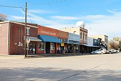
Van Alstyne, Texas
Van Alstyne, Texas | |
|---|---|
 | |
| Motto(s): "Proud Past, Bright Future" | |
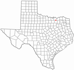
 Location of Van Alstyne, Texas | |
 | |
| Coordinates: 33°25′17″N 96°35′00″W / 33.42139°N 96.58333°W | |
| Country | United States |
| State | Texas |
| Counties | Grayson, Collin |
| Government | |
| • Type | Council-manager |
| • Mayor | Jim Atchison |
| • City Manager | Lane Jones |
| Area | |
• City | 5.33 sq mi (13.81 km2) |
| • Land | 5.33 sq mi (13.81 km2) |
| • Water | 0.00 sq mi (0.00 km2) |
| • Metro | 979 sq mi (2,536 km2) |
| Elevation | 781 ft (238 m) |
| Population (2020) | |
• City | 4,369 |
• Estimate (2023)[3] | 8,500 |
| • Density | 820/sq mi (320/km2) |
| • Metro | 120,877 |
| • Metro density | 130/sq mi (50/km2) |
| Time zone | UTC-6 (Central (CST)) |
| • Summer (DST) | UTC-5 (CDT) |
| ZIP code | 75495 |
| Area codes | 903, 430 |
| FIPS code | 48-74924[4] |
| GNIS feature ID | 2412145[2] |
| Website | www |
Van Alstyne is a small, affluent, and rapidly growing city in Grayson and Collin Counties in the U.S. state of Texas. The population was 3,046 at the 2010 census,[5] up from 2,502 at the 2000 census. As of the 2020 United States census, the population grew to 4,369 people. 2023 estimates place the resident count at 5,378.[6] The Grayson County portion of Van Alstyne is part of the Sherman–Denison Metropolitan Statistical Area.
History
[edit]Drawn by the economic promise of the Houston and Texas Central Railway,[7] Van Alstyne was founded in 1873 by settlers from the nearby community of Mantua. The community was named for Marie Van Alstyne, a Houston socialite and major shareholder in the railroad company.[8]
A post office was opened that same year, and by the time Van Alstyne officially incorporated in 1890, the town had grown to a population of 400, supported by a thriving rural economy, a local newspaper, and a college. By the turn of the century, the population had reached 1,940, and the town supported a range of businesses, including multiple banks, a grain elevator, a roller mill, and a chemical company.
Throughout the 20th century, Van Alstyne remained a vibrant rural hub for agriculture, trade, manufacturing, and banking. Its economy, along with strong community institutions, sustained the town through decades of slow, steady development and moderate population growth.[7]
In May 2022, citizens passed a resolution establishing the first city charter, making Van Alstyne a Texas home rule city.[9] Van Alstyne is a council/manager form of government with a mayor and 6 city council members each elected at large by place to three year terms.
Geography
[edit]Van Alstyne is located in southeastern Grayson County. The city limits extend south slightly into Collin County.
The U.S. Route 75 freeway runs through the western side of the city, with access from Exits 50 and 51. US 75 leads north 27 miles (43 km) to Denison and south 50 miles (80 km) to the center of Dallas. Van Alstyne's immediate neighbors are Anna to the south and Howe to the north.
According to the United States Census, Van Alstyne has a total area of 4.1 square miles (10.5 km2), all land.[5]
Demographics
[edit]| Census | Pop. | Note | %± |
|---|---|---|---|
| 1870 | 213 | — | |
| 1880 | 737 | 246.0% | |
| 1890 | 737 | 0.0% | |
| 1900 | 1,940 | 163.2% | |
| 1910 | 1,441 | −25.7% | |
| 1920 | 1,588 | 10.2% | |
| 1930 | 1,453 | −8.5% | |
| 1940 | 1,650 | 13.6% | |
| 1950 | 1,649 | −0.1% | |
| 1960 | 1,608 | −2.5% | |
| 1970 | 1,981 | 23.2% | |
| 1980 | 1,860 | −6.1% | |
| 1990 | 2,090 | 12.4% | |
| 2000 | 2,502 | 19.7% | |
| 2010 | 3,046 | 21.7% | |
| 2020 | 4,369 | 43.4% | |
| 2023 (est.) | 6,782 | 55.2% | |
| U.S. Decennial Census[10] | |||
| Race | Number | Percentage |
|---|---|---|
| White (NH) | 3,220 | 73.7% |
| Black or African American (NH) | 152 | 3.48% |
| Native American or Alaska Native (NH) | 41 | 0.94% |
| Asian (NH) | 37 | 0.85% |
| Some Other Race (NH) | 3 | 0.07% |
| Mixed/Multi-Racial (NH) | 206 | 4.72% |
| Hispanic or Latino | 710 | 16.25% |
| Total | 4,369 |
As of the 2020 United States census, there were 4,369 people, 1,307 households, and 1,108 families residing in the city.
Education
[edit]Public schools
[edit]Students are served by the Van Alstyne Independent School District. Schools in the district include Partin Elementary School (formerly Van Alstyne Elementary School), Sanford Elementary School, Van Alstyne Middle School, Van Alstyne Junior High School and Van Alstyne High School.[15]
Colleges
[edit]Grayson County College operates a branch campus in Van Alstyne.

Transportation
[edit]US Highway 75 and Texas State Highway 5 runs north-south through Van Alstyne with 75 being on the western edge while SH 5 runs straight through Van Alstyne. FM 121 runs east-west through Van Alstyne.
Roads
[edit] US 75 Runs north-south, goes through Howe in the north and Anna in the south.
 SH 5 Runs north-south, goes through Howe in the north and Anna in the south.
 FM 121 Runs east-west. To the west is Gunter and to the east is Pilot Grove.[16]
References
[edit]- ^ "2019 U.S. Gazetteer Files". United States Census Bureau. Retrieved August 7, 2020.
- ^ a b U.S. Geological Survey Geographic Names Information System: Van Alstyne, Texas
- ^ "Population and Housing Unit Estimates". United States Census Bureau. May 24, 2020. Retrieved May 27, 2020.
- ^ "U.S. Census website". United States Census Bureau. Retrieved January 31, 2008.
- ^ a b "Geographic Identifiers: 2010 Census Summary File 1 (G001): Van Alstyne city, Texas". U.S. Census Bureau, American Factfinder. Archived from the original on February 13, 2020. Retrieved August 3, 2015.
- ^ "Census profile: Van Alstyne, TX". Census Reporter. Retrieved August 6, 2025.
- ^ a b "Van Alstyne, Texas". Texas State Historical Association. Retrieved July 27, 2012.
- ^ "Profile for Van Alstyne, Texas, TX". ePodunk. Retrieved July 27, 2012.
- ^ "LOCAL GOVERNMENT CODE CHAPTER 9. HOME-RULE MUNICIPALITY". statutes.capitol.texas.gov. Retrieved August 6, 2025.
- ^ "Census of Population and Housing". Census.gov. Retrieved June 4, 2015.
- ^ "City and Town Population Totals: 2020-2023". Census.gov. United States Census Bureau. Retrieved November 15, 2024.
- ^ "Explore Census Data". data.census.gov. Retrieved May 22, 2022.
- ^ https://www.census.gov/ [not specific enough to verify]
- ^ "About the Hispanic Population and its Origin". www.census.gov. Retrieved May 18, 2022.
- ^ "Van Alstyne Independent School District". Van Alstyne Independent School District. Archived from the original on February 29, 2012. Retrieved July 29, 2012.
- ^ Texas Official Travel Map

