User:Olahus

| This is a Wikipedia user page. This is not an encyclopedia article or the talk page for an encyclopedia article. If you find this page on any site other than Wikipedia, you are viewing a mirror site. Be aware that the page may be outdated and that the user whom this page is about may have no personal affiliation with any site other than Wikipedia. The original page is located at https://en.wikipedia.org/wiki/User:Olahus. |

Beliefs
|

| |||
Hi! I am the user Olahus. I am interested in the history and geography of Central, Eastern and Southeastern Europe.
I am a registered user since May 2006.

Kumaon is a revenue and administrative division in the Indian state of Uttarakhand. Historically known as Manaskhand and Kurmanchal, the Kumaon region has been ruled by several dynasties over the course of its history, most notably the Katyuri and the Chand. In 1790, the Kingdom of Kumaon was invaded and annexed by the Gorkhas, from whom it was conquered by the British East India Company in 1815, following which it became part of the Ceded and Conquered Provinces (which later became the United Provinces). After Indian independence in 1947, it remained part of the state of Uttar Pradesh until 2000, when the state of Uttarakhand was created as a result of the Uttarakhand movement. The people of Kumaon are known as Kumaonis and speak the Kumaoni language. This picture shows a panoramic view of the Kumaon Himalayas as seen from the hill station and town of Ranikhet, with mountains such as Trisul (7,120 m, 23,360 ft), Nanda Devi (7,817 m, 25,646 ft), Nanda Kot (6,861 m, 22,510 ft), Panchachuli (6,904 m, 22,651 ft), and other peaks prominently visible.Photograph credit: Harshit Rautela; edited by UnpetitproleX
Images uploaded by me
[edit]Maps created by me
[edit]
.PNG)
.PNG)
.PNG)
.PNG)
.PNG)


.png)

.PNG)
.PNG)
.PNG)


.PNG)


Scanned images
[edit]-
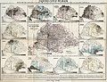
 Ethnic map of the Balkan Peninsula (1898)
 -
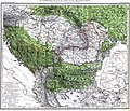
 The Austrian Empire during the XVII century
 -
 The Carolingian Empire after the Treaty of Verdun
 -
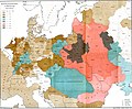
 Ethnic map of European Russia before the First World War
 -
 Ethnographic map of Dobruja (1918)
 -
 The Principality of Montenegro in 1862
 -
 Major Lithuanian linguistic areal in 1876.
 -
 Ethnic Germans in Hungary and parts of adjacent Austrian territories, census 1890
 -
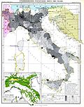 Demographic map of Italy and surroundung regions (1859)
 -
 Linguistic map of Slovenia and surrounding regions (census 1880)
 -
 Linguistic map of Istria (census 1880)
 -
 The Romanian Old Kingdom (1901)
 -
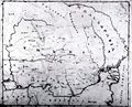
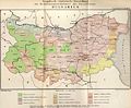
 Bulgaria in 1901
 -
 General map of Rumania (1967)
 -
 Confessions in Central Europe
 -
 Bukovina in 1901
 -
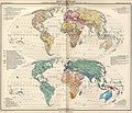
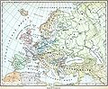 Political map of Europe (1899)
 -
 Political map of Asia (1899)
 -
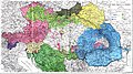
 Main subdivisions of Austria-Hungary (1899).
 -
 Political map of South America (1899)
 -
 Extermination of the American Bison to 1889
 -
 The density of the railway net in Europe (1902)
 -
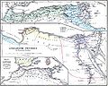
 Map of Greece and European Turkey (1829)
 -
-
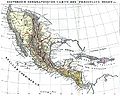
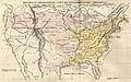 The United States in 1829
 -
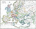
 Europe in 1828
 -
 Austria-Hungary in 1828
 -
 The German confederation (1828)
 -
 The Ottoman Empire in Asia (1829)
 -
 The American continent in 1828
 -
 Africa in 1828
 -
 Asia in 1829
 -
 The Russian Empire in 1828
 -
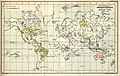
 The world map (1829)
 -
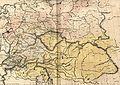
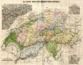 Historical map of Switzerland
 -
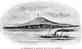
 The Lake Lucerne (1829)
 -

-

-

-

-

-
-

-

-
-

-
-

-

-
-

-

-
-
-

-

-

-

-

-

-

-

-

-

-

-

-
-
-

-

-

-
-
-

-
-

-
-

-

-
-

-

-

-

-

-
-
-

-

-
-

-

-
 Ethnographic map of the Epirus region, 1878. Greek point of view
 -
 Walser settlements in northwestern Italy


.JPG)

.JPG)


.jpg)
.JPG)


.JPG)


.JPG)
.jpg)
.JPG)


.JPG)


_1892.JPG)

.JPG)
.jpg)

.JPG)


.jpg)

.JPG)

.jpg)


.JPG)
.jpg)

.jpg)
.jpg)


.jpg)


.JPG)


