Torre di Toblin
| Torre di Toblin | |
|---|---|
| German: Toblinger Knoten[1] | |
 West aspect | |
| Highest point | |
| Elevation | 2,630 m (8,629 ft)[2] |
| Prominence | 235 m (771 ft)[2] |
| Parent peak | Zwölferkofel[2] |
| Isolation | 1.394 km (0.866 mi)[2] |
| Coordinates | 46°38′31″N 12°18′29″E / 46.641894°N 12.308013°E[1] |
| Geography | |
 Torre di Toblin Location in Italy | |
 | |
| Interactive map of Torre di Toblin | |
| Country | Italy |
| Province | South Tyrol |
| Protected area | Drei Zinnen / Tre Cime Nature Park |
| Parent range | Dolomites Sexten Dolomites[2] |
| Topo map | Tabacco 010 Sextener Dolomiten/Dolomiti di Sesto |
| Geology | |
| Rock age | Triassic |
| Rock type | Dolomite |
| Climbing | |
| First ascent | 1885 |
Torre di Toblin is a mountain in the province of South Tyrol in northern Italy.
Description
[edit]Torre di Toblin, also known as Toblinger Knoten in German, is a 2,630-meter-elevation (8,629-foot) summit in the Sexten Dolomites subrange of the Dolomites, a UNESCO World Heritage Site. Set in the Trentino-Alto Adige/Südtirol region, the peak is located seven kilometers (4.35 miles) south-southwest of the village of Sexten, and the peak is within Drei Zinnen / Tre Cime Nature Park.[3] Precipitation runoff from the peak drains into tributaries of the Drava.[1] Topographic relief is significant as the summit rises 630 meters (2,067 feet) above the Rienz Valley in one kilometer (0.6 mile). The first ascent of the east summit was made in 1885 by Michael Innerkofler and Wenzel Eckerth via the northeast side, whereas the west summit was first climbed on July 22, 1892, by Sepp Innerkofler and Leon Treptow via the northwest ridge.[4] The Italian toponym translates as "Toblin Tower." The peak was a strategic artillery observation post used by the Austro-Hungarian Army during the White War of World War I.[5][6] The nearest higher neighbor is Monte Paterno, 1.39 kilometers (0.87 mile) to the south-southeast.[2]
Climate
[edit]Based on the Köppen climate classification, Torre di Toblin is located in an alpine climate zone with long, cold winters, and short, mild summers.[7] Weather systems are forced upwards by the mountains (orographic lift), causing moisture to drop in the form of rain and snow. The months of June through September offer the most favorable weather for visiting or climbing in this area.[8]
Gallery
[edit]-
 Torre di Toblin centered
 -

-
 Torre di Toblin, with Haunold in background
 -
 Torre di Toblin to left
 -
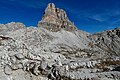 West aspect
 -
 South aspect
 -
 Torre di Toblin directly above Sasso di Sesto with Rifugio Locatelli to right


_-_123_(50587316201).jpg)
_-_115_(50586576283).jpg)


See also
[edit]References
[edit]- ^ a b c "Torre di Toblin, Italy". Peakbagger.com. Retrieved November 13, 2025.
- ^ a b c d e f "Toblinger Knoten". peakvisor.com. Retrieved November 13, 2025.
- ^ Drei Zinnen / Tre Cime Nature Park, nature-parks.province.bz.it/en, Retrieved November 12, 2025.
- ^ Torre di Toblin / Toblinger Knoten, Camptocamp.org, Retrieved November 13, 2025.
- ^ Peter Kübler, Hugo Reider: Kampf um die Drei Zinnen. The heart of the Sesto Dolomites 1915–1917 and today. Publisher: Reider Touristik K.G. 1st edition. Sesto 2011, ISBN 978-88-902466-2-3, pp.132–157.
- ^ Paolo Morisi, Hell in the Trenches, Helion and Company, 2022, ISBN 9781912866168, p. 314.
- ^ Peel, M. C.; Finlayson, B. L.; McMahon, T. A. (2007). "Updated world map of the Köppen−Geiger climate classification". Hydrol. Earth Syst. Sci. 11 (5): 1633–1644. Bibcode:2007HESS...11.1633P. doi:10.5194/hess-11-1633-2007. ISSN 1027-5606.
- ^ Best Time to Visit the Dolomites (+ Months to Avoid), Moonhoneytravel.com, Retrieved November 13, 2025.
External links
[edit]- Weather forecast: Torre di Toblin
Places adjacent to Torre di Toblin | ||||||||||||||||
|---|---|---|---|---|---|---|---|---|---|---|---|---|---|---|---|---|
| ||||||||||||||||