Portal:New Guinea
The New Guinea Portal
Introduction
Native name: Papua, Niugini, Niu Gini | |
|---|---|
 | |
| Geography | |
| Location | Oceania (Melanesia) |
| Archipelago | Melanesia and Malay Archipelago |
| Area | 785,753 km2 (303,381 sq mi) |
| Area rank | 2nd |

New Guinea (Tok Pisin: Niugini; Hiri Motu: Niu Gini; Indonesian: Papua, fossilized Nugini, also known as Papua or historically Irian) is the world's second-largest island, with an area of 785,753 km2 (303,381 sq mi). Located in Melanesia in the southwestern Pacific Ocean, the island is separated from Australia by the 150-kilometre (81-nautical-mile; 93-mile) wide Torres Strait, though both landmasses lie on the same continental shelf, and were united during episodes of low sea level in the Pleistocene glaciations as the combined landmass of Sahul. Numerous smaller islands are located to the west and east. The island's name was given by Spanish explorer Yñigo Ortiz de Retez during his maritime expedition of 1545 due to the perceived resemblance of the indigenous peoples of the island to those in the African region of Guinea. (Full article...)
Papua New Guinea (PNG), officially the Independent State of Papua New Guinea, is an island country in Oceania that comprises the eastern half of the island of New Guinea and offshore islands in Melanesia, a region of the southwestern Pacific Ocean north of Australia. It has a land border with Indonesia to the west and maritime borders with Australia to the south and the Solomon Islands to the east. Its capital is Port Moresby. The country's 462,840 km2 (178,700 sq mi) includes a large mainland and hundreds of islands. (Full article...)
Western New Guinea, also known as Papua, Indonesian New Guinea, and Indonesian Papua, is the western half of the island of New Guinea, formerly Dutch and granted to Indonesia in 1962. Given the island is alternatively named Papua, the region is also called West Papua (Indonesian: Papua Barat). It is one of the seven geographical units of Indonesia in ISO 3166-2:ID. (Full article...)
Selected article -
-

Corruption in Papua New Guinea is rife.
According to The Economist, "PNG's governments are notorious for corruption, and ever run the risk of turning the state into a fully-fledged kleptocracy".
Transparency International's Corruption Perceptions Index scores 180 countries according to the perceived corruption of their public sector on a scale from 0 ("highly corrupt") to 100 ("very clean"). Those countries are then ranked by their score; the country ranked first is perceived to have the most honest public sector. In the 2024 Index, Papua New Guinea scored 31 and ranked 127th. For comparison with regional scores, the best score among the countries of the Asia Pacific region was 84, the average score was 44 and the worst score was 16. For comparison with worldwide scores, the best score was 90 (ranked 1), the average score was 43, and the worst score was 8 (ranked 180).
Papua New Guinea is below the satisfactory levels set by the United Nations Convention against Corruption (UNCAC), according to a report submitted by Transparency International Papua New Guinea (TIPNG) in 2011. TIPNG’s report found that in many cases, anti-corruption bodies in PNG were restricted by shortcomings in financial resources. (Full article...) -

The monarchy of Papua New Guinea is a system of government in which a hereditary monarch is the sovereign and head of state of Papua New Guinea. The current Papua New Guinean monarch and head of state, since 8 September 2022, is King Charles III. As sovereign, he is the personal embodiment of the Papua New Guinean Crown. Although the person of the sovereign is equally shared with 14 other independent countries within the Commonwealth of Nations, each country's monarchy is separate and legally distinct. As a result, the current monarch is officially titled King of Papua New Guinea and, in this capacity, he and other members of the royal family undertake public and private functions domestically and abroad as representatives of Papua New Guinea. However, the King is the only member of the royal family with any constitutional role.
All executive authority is vested in the monarch, and royal approval is required for letters patent and Orders in Council to have legal effect. But the authority for these acts stems from the country's populace, in which sovereignty is vested, and the monarch's direct participation in any of these areas of governance is limited. Most of the powers are exercised by the elected members of parliament, the ministers of the Crown generally drawn from amongst them, and the judges and justices of the peace. Other powers vested in the Crown, such as dismissal of a prime minister, are significant but are treated only as reserve powers and as an important security part of the role of the monarchy.
The Crown today primarily functions as a guarantor of continuous and stable governance and a nonpartisan safeguard against the abuse of power. While some powers are exercisable only by the sovereign, most of the monarch's operational and ceremonial duties are exercised by his representative, the governor-general of Papua New Guinea. (Full article...) -
The People's National Congress is a political party in Papua New Guinea. Its former leader Bill Skate served as prime minister from 1997 to 1999 and as speaker of Parliament from 2002 to 2004. Skate died in 2006 and the party was led by Peter O'Neill until 2022. PNC originated from the National Capital District where former leader (late Bill Skate) was the Governor of NCD and the Parliamentary Member. The party had 16 members in the 113-seat National Parliament of Papua New Guinea as of December 2022. (Full article...)
-
Sir Julius Chan (29 August 1939 – 30 January 2025) was a Papua New Guinean politician who served as Prime Minister of Papua New Guinea from 1980 to 1982 and from 1994 to 1997. He was Member of Parliament for New Ireland Province, having won the seat in the 2007 national election. He was also the Governor of New Ireland Province from 2007 until his death in 2025. On 26 May 2019, Prime Minister Peter O'Neill announced he would soon resign and that he wished for Sir Julius to succeed him. An outgoing Prime Minister does not, however, have the power to appoint his successor, and the following day O'Neill delayed his own formal resignation. He was also a leading figure in his country during the years-long Bougainville conflict. (Full article...) -
Puncak Trikora (literally "Peak People's Triple Command") is a 4,730 or 4,750-metre-high (15,584 ft) mountain in the Highland Papua province of Indonesia on New Guinea. It lies in the eastern part of the Sudirman (Nassau) Range of the Maoke Mountains.
Behind Puncak Jaya (Carstensz Pyramid) at 4,884 m (16,024 ft), it is either the second or third highest mountain on the island of New Guinea and the Australasian continent. As such it appears on some Seven Second Summits lists, although SRTM-data support that Puncak Mandala (Juliana Peak) in the Jayawijaya (Orange) Range is higher with 4,760 m (15,617 ft). (Full article...) -
Papua New Guinea is home to several protected areas, which receive protection because of their environmental, cultural or similar value.
The total area of Papua New Guinea protected territories is 14,330 km2 (5,530 sq mi), which amounts to approximately 3.07% of the country's territory. The total number of protected areas as 2018 is 71.
The effort by the PNG government to protect biodiversity has resulted in 44 existing terrestrial protected areas using the International Union for the Conservation of Nature and Natural Resources (IUCN) categories. These protected areas account for 1.6% of the total land area. A study of biodiversity identified a further 398 areas as candidates for conservation. This would increase the total protected areas to 16.8% of the total country area. (Full article...) -
The Battle of Wau, 29 January – 4 February 1943, was a battle in the New Guinea campaign of World War II. Forces of the Empire of Japan sailed from Rabaul and crossed the Solomon Sea and, despite Allied air attacks, successfully reached Lae, where they disembarked. Japanese troops then advanced overland on Wau, an Australian base that potentially threatened the Japanese positions at Salamaua and Lae. A race developed between the Japanese moving overland, hampered by the terrain, and the Australians, moving by air, hampered by the weather. By the time the Japanese reached the Wau area after a trek over the mountains, the Australian defenders had been greatly reinforced by air. In the battle that followed, despite achieving tactical surprise by approaching from an unexpected direction, the Japanese attackers were unable to capture Wau. (Full article...) -

The Coral Triangle and countries participating in the Coral Triangle Initiative
The Coral Triangle (CT) is a roughly triangular area in the tropical waters around Indonesia, Malaysia, Papua New Guinea, the Philippines, Solomon Islands, and Timor-Leste. This area contains at least 500 species of reef-building corals in each ecoregion. The Coral Triangle is located between the Pacific and Indian oceans and encompasses portions of two biogeographic regions: the Indonesian-Philippines Region, and the Far Southwestern Pacific Region. As one of eight major coral reef zones in the world, the Coral Triangle is recognized as a global centre of marine biodiversity and a global priority for conservation. Its biological resources make it a global hotspot of marine biodiversity. Known as the "Amazon of the seas" (by analogy to the Amazon rainforest in South America), it covers 5.7 million square kilometres (2,200,000 sq mi) of ocean waters. It contains more than 76% of the world's shallow-water reef-building coral species, 37% of its reef fish species, 50% of its razor clam species, six out of seven of the world's sea turtle species, and the world's largest mangrove forest. The epicenter of that coral diversity is found in the Bird's Head Seascape of Indonesian Papua, which hosts 574 species (95% of the Coral Triangle, and 72% of the world's total). In 2014, the Asian Development Bank (ADB) reported that the gross domestic product of the marine ecosystem in the Coral Triangle is roughly $1.2 trillion per year and provides food to over 120 million people. According to the Coral Triangle Knowledge Network, the region annually brings in about $3 billion in foreign exchange income from fisheries exports, and another $3 billion from coastal tourism revenues.
The World Wide Fund for Nature considers the region a top priority for marine conservation, and is addressing ecological threats to the region through its Coral Triangle Program, launched in 2007. The center of biodiversity in the Triangle is the Verde Island Passage in the Philippines. Coral reef area in the region to have been declared a UNESCO World Heritage Site are Tubbataha Reef Natural Park in the Philippines and Raja Ampat UNESCO Global Geopark in Indonesia. (Full article...) -

Greater bird-of-paradise
The fauna of New Guinea comprises a large number of species of mammals, reptiles, birds, fish, invertebrates and amphibians.
As the world's largest and highest tropical island, New Guinea occupies less than 0.5% of world's land surface, yet supports a high percentage of global biodiversity. Approximately 4,624 vertebrate species inhabit the island of New Guinea and its surrounding waters, which constitutes about 8% of the recognized world vertebrates. This ranges from an estimated 4% of the world's lizards and mammals, to about 10% of the world's fish species.
The numbers of global and New Guinea invertebrate species are poorly known, and thus an accurate comparison is difficult. Butterflies are the best known invertebrate group, and are represented in New Guinea by about 735 species, which is about 4.2% of the world total of 17,500 species. (Full article...) -
Kiwai Island is the largest island in the Fly River delta, Papua New Guinea. It is 59 km (37 mi) long along the northwest–southeast axis from Wamimuba Point in the northwest to the village of Saguane (Sanguane) in the south, and up to 9 km (5.6 mi) wide, with an average width of 5.6 km (3.5 mi). Its area is 359 km2 (139 sq mi). Neighboring Purutu and Wabuda Islands to the north and northeast are also among the three largest islands in the Fly River delta. A language study mentioned a population of about 4,500, but the census of population of 2000 showed only 2,092 inhabitants. (Full article...) -
Lesbian, gay, bisexual, and transgender (LGBT) people in Papua New Guinea face legal challenges not experienced by non-LGBTQ residents. Male same-sex sexual activity is illegal, punishable by up to 14 years' imprisonment. The law is rarely enforced, but arrests still do happen, having occurred in 2015 and 2022. There are no legal restrictions against lesbian sex in the country.
Attitudes towards LGBT people are greatly influenced by Christian churches, as a majority of Papua New Guineans are Christian. Historically, gay men had certain societal roles. They would take on traditional female roles such as cooking and would participate with women in traditional festivals. However, some tribes were observed to have practiced ritual homosexuality, such as the Etoro, Kaluli, and Sambia peoples.
A lot of the attitudes towards LGBT people are also influenced by Australia's early occupation of Papua New Guinea. The Australian criminal law, originally derived from the Queensland Criminal Code created during British colonization, was extended to Papua New Guinea. Despite the Australian states starting to decriminalize same-sex sexual activity in 1975, Papua New Guinea retained this provision due to gaining independence in the same year, resulting in the continued criminalization of such activity there. (Full article...) -
The Kaluli creation myth is a traditional creation myth of the Kaluli people of Papua New Guinea. In the version as was recorded by anthropologist and ethnographer Edward L. Shieffelin whose first contact with them took place in the late 1960s. The story begins in a time the Kaluli call hena madaliaki, which translates "when the land came into form." During the time of hena madaliaki people covered the earth but there was nothing else: no trees or plants, no animals, and no streams. With nothing to use for food or shelter, the people became cold and hungry. Then one man among them (alternative accounts give two) gathered everyone together and delegated different tasks. He directed one group to become trees and they did. He directed another to become sago, yet another to be fish, another banana and so forth until the world was brimming with animals, food, streams, mountains and all other natural features. There were only a few people left and they became the ancestors of present-day human beings.
The Kaluli describe this story as "the time when everything alə bano ane" which means roughly "the time when everything divided". This concept of all world phenomena as a result of a "splitting" has many echos in Kaluli thought and cultural practices. In the Kaluli world view, all of existence is made from people who differentiated into different forms. Animals, plants, streams and people are all the same except in the form they have assumed following this great split. Death is another splitting. The Kaluli have no concept of a transcendent, sacred domain that is spiritual or in any fundamental way distinct from the natural, material world; instead death is another event that divides beings through the acquisition of new forms which are unrecognizable to the living.
The Kaluli are an indigenous people whose first contact with contemporary western civilization began in the 1940s. Following extensive Christian missionary efforts in the region, variants of the traditional creation story have adopted a few Christian elements. Prior to contact, the Kaluli story described creation as a pragmatic solution to problems of cold and hunger, and the efforts were initiated by one or two ordinary and unnamed men rather than any deity or deities. The Kaluli have since tended to identify one or both of them as "Godeyo" (God) and "Yesu" (Jesus Christ). (Full article...) -

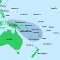
Map of Melanesia, showing its location within Oceania
Melanesia (UK: /ˌmɛləˈniːziə/ ⓘ, US: /ˌmɛləˈniːʒə/) is a subregion of Oceania in the southwestern Pacific Ocean. It extends from New Guinea in the west to the Fiji Islands in the east, and includes the Arafura Sea.
The region includes the four independent countries of Fiji, Vanuatu, Solomon Islands, and Papua New Guinea. It also includes the Indonesian part of New Guinea, the French overseas collectivity of New Caledonia, and the Torres Strait Islands. Almost all of the region is in the Southern Hemisphere; only a few small islands that are not politically considered part of Oceania—specifically the northwestern islands of Western New Guinea—lie in the Northern Hemisphere.
The name Melanesia (French: Mélanésie) was first used in 1832 by French navigator Jules Dumont d'Urville: he coined the terms Melanesia and Micronesia to go alongside the pre-existing Polynesia to designate what he viewed as the three main ethnic and geographical regions forming the Pacific. (Full article...) -
The Huon Peninsula campaign was a series of battles fought in north-eastern Papua New Guinea in 1943–1944 during the Second World War. The campaign formed the initial part of an offensive that the Allies launched in the Pacific in late 1943 and resulted in the Japanese being pushed north from Lae to Sio on the northern coast of New Guinea over the course of a four-month period. For the Australians, a significant advantage was gained through the technological edge that Allied industry had achieved over the Japanese by this phase of the war, while the Japanese were hampered by a lack of supplies and reinforcements due to Allied interdiction efforts at sea and in the air.
The campaign was preceded by an amphibious landing by troops from the Australian 9th Division east of Lae on 4 September 1943. This was followed by an advance west along the coast towards the town where they were to link up with 7th Division advancing from Nadzab. Meanwhile, Australian and US forces mounted diversionary attacks around Salamaua. Heavy rain and flooding slowed the 9th Division's advance, which had to cross several rivers along the way. The Japanese rear guard also put up a stiff defence and, as a result, Lae did not fall until 16 September, when troops from the 7th Division entered it ahead of the 9th, and the main body of the Japanese force escaped north. Less than a week later, the Huon Peninsula campaign was opened as the Australians undertook another amphibious landing further east, aimed at capturing Finschhafen.
Following the landing at Scarlet Beach, the Allies set about moving south to secure Finschhafen, which saw fighting around Jivevaneng also. In mid-October, the Japanese launched a counterattack against the Australian beachhead around Scarlet Beach, which lasted for about a week and resulted in a small contraction of the Australian lines and a splitting of their force before it was defeated. After this, the Australians regained the initiative and began to pursue the Japanese who withdrew inland towards the high ground around Sattelberg. Amidst heavy fighting and a second failed Japanese counterattack, Sattelberg was secured in late November and the Australians began an area advance to the north to secure a line between Wareo and Gusika. This was completed by early December, and was followed by an advance by Australian forces along the coast through Lakona to Fortification Point, overcoming strong Japanese forces fighting delaying actions. (Full article...) -

The disputed territory of West New Guinea
The West New Guinea dispute (1950–1962), also known as the West Irian dispute, was a diplomatic and political conflict between the Netherlands and Indonesia over the territory of Dutch New Guinea. While the Netherlands had ceded sovereignty over most of the Dutch East Indies to Indonesia on 27 December 1949 following an independence struggle, it retained control over its colony on the western half of New Guinea. The Indonesian government claimed this territory as well, on the basis that it had belonged to the Dutch East Indies and that the new Republic of Indonesia was the legitimate successor to the former Dutch colony.
During the first phase of the dispute (1950–1954), Indonesia pursued bilateral negotiations with the Netherlands. During the second phase (1954–1958), Indonesia attempted to raise support for its territorial claims in the United Nations General Assembly. During the third phase (1960–1962), Indonesia pursued a policy of confrontation against the Netherlands which combined diplomatic, political, and economic pressure with limited military force. The final stage of the confrontation with Indonesia also involved a planned military invasion of the territory. The Indonesians also secured military weapons and political and military support from the Soviet Union, which induced the United States to intervene in the conflict as a third-party mediator between Indonesia and the Netherlands. Following the New York Agreement on 15 August 1962, the Netherlands, under U.S. pressure, handed West New Guinea over to a United Nations Temporary Executive Authority, which subsequently handed the territory over to Indonesia on 1 May 1963. Following a controversial plebiscite in 1969, West New Guinea was formally integrated into Indonesia. (Full article...)


.jpeg)
_and_west_ridge_by_Christian_Stangl_flickr.jpg)


.jpg)

Did you know (auto-generated)

- ... that Australian official Jack Emanuel was awarded the George Cross in 1971 after being stabbed to death whilst trying to resolve a land dispute with the Tolai people of New Guinea?
- ... that Dorkas Tokoro-Hanasbey, the only female member of the New Guinea Council, arrived thirty minutes late to her inauguration ceremony?
- ... that David Dexter, who wrote the New Guinea volume in the series Australia in the War of 1939–1945, was a commando who served in East Timor and New Guinea?
- ... that artifacts of Papua New Guinean art were called "living spirits with fixed abodes"?
- ... that Australiformis semoni is a parasite that infests marsupials in Australia and New Guinea and whose infestation could cause debilitating ulcerative granulomatous gastritis?
- ... that in 1984, more than 10,000 Papuans from West Papua crossed into Papua New Guinea as refugees due to a government crackdown?
General images -
-
 Dutch colonial civil servant in the Baliem Valley, 1958 (from Western New Guinea)
 -
 New Guinea crocodile (from New Guinea)
 -
 Trans-New Guinea languages (multi-coloured), Austronesian languages (gold), and other languages (grey) (from Western New Guinea)
 -
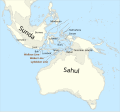 The continent of Sahul before the rising ocean sundered Australia and New Guinea after the last ice age (from New Guinea)
 -
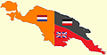 New Guinea from 1884 to 1919. The Netherlands controlled the western half of New Guinea, Germany the north-eastern part, and Britain the south-eastern part. (from New Guinea)
 -
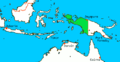
 New Guinea located in relation to Melanesia (from New Guinea)
 -
 Free West Papua protest in Melbourne, Australia, August 2012. (from Western New Guinea)
 -

-
-
 Regions of Oceania: Australasia, Polynesia, Micronesia, and Melanesia. Physiographically, Australasia includes the Australian landmass (including Tasmania), New Zealand, and New Guinea (from New Guinea)
 -
 Papuans on the Lorentz River, photographed during the third South New Guinea expedition in 1912–13 (from New Guinea)
 -
 A Japanese military map of New Guinea from 1943 (from New Guinea)
 -
 Grasberg Mine in Mimika Regency. Mining is the most important sector in the province (from Western New Guinea)
 -
 Skouw border checkpoint, on the Indonesia-Papua New Guinea border (from Western New Guinea)
 -
 Handover ceremony of West Irian Governorship from Jan Bonay to Frans Kaisiepo, 1965 (from Western New Guinea)
 -
 Coral reefs in Papua New Guinea (from New Guinea)
 -
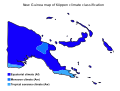 Papua New Guinea map of Köppen climate classification (from New Guinea)
 -

-

-
 The raggiana bird-of-paradise is native to New Guinea. (from New Guinea)
 -
 Mount Bosavi (from New Guinea)
 -
 Jayapura, the most populous and largest city on the island of New Guinea (Papua) (from New Guinea)
 -
 Since 2002, display of the flag of West Papua is allowed in West Papua only if accompanied by, and not raised higher than, the flag of Indonesia. (from Western New Guinea)
 -
 Dutch expeditions in Netherlands New Guinea 1907–1915. (from Western New Guinea)
 -
Regions of Oceania: Australasia, Polynesia, Micronesia, and Melanesia. Australasia includes the Australian landmass (including Tasmania), New Zealand, and New Guinea. (from History of Papua New Guinea)
-
 Yali in the Yahukimo Regency (from Western New Guinea)
 -
 Map of New Guinea, with place names as used in English in the 1940s (from New Guinea)
 -

-
Map showing the combined landmass of Sahul formed during Pleistocene glacations (from New Guinea)
-
 Fishing boats in Biak (from Western New Guinea)
 -
 Western New Guinea was formally annexed by Indonesia in 1969. (from New Guinea)
 -
 The Nagarakertagama mentioned a region in the east called Wanin, present-day Onin Peninsula in the Fakfak Regency, West Papua (from Western New Guinea)
 -
 The lowland rainforest of the Western New Guinea (from Western New Guinea)
 -
 The floristic region of Malesia (from New Guinea)
 -
 An Australian soldier, Private George "Dick" Whittington, is aided by Papuan orderly Raphael Oimbari, near Buna on 25 December 1942. (from History of Papua New Guinea)
 -
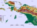
 Political divisions of New Guinea (2006) (from New Guinea)
 -
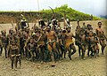
 Culture parade in Biak (from Western New Guinea)
 -
 Female gable image, Sawos people, Oceanic art in the Bishop Museum (from History of Papua New Guinea)
 -
 Australian forces attack Japanese positions during the Battle of Buna–Gona, 7 January 1943. (from History of Papua New Guinea)
 -
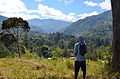 Highlands of Papua New Guinea (from New Guinea)
 -
 Sago is a typical Papuan food, which is usually made into papeda. (from Western New Guinea)
 -
 Group of natives at Mairy Pass. Mainland of British New Guinea in 1885. (from New Guinea)
 -
-
 Australian troops at Milne Bay, Papua.The Australian garrison was the first to inflict defeat on the Imperial Japanese Army during World War II at the Battle of Milne Bay of Aug–Sep 1942. (from History of Papua New Guinea)
 -

-
 A section of Trans-Papua Highway connecting Deiyai and Mimika in Central Papua (from Western New Guinea)
 -
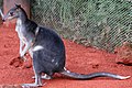 Dorcopsis hageni, native to northern region of New Guinea. (from Western New Guinea)
 -
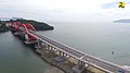 Youtefa Bridge, currently the longest bridge in Papua (from Western New Guinea)
 -
 Sentani International Airport in Jayapura is the principal point of entry to Papua (from Western New Guinea)
 -
 Fort Du Bus in 1828 (from Western New Guinea)
 -
 The rugged and mountainous topography of Western New Guinea. (from Western New Guinea)
 -
 Koiari village near Bootless Inlet, British New Guinea (from History of Papua New Guinea)
 -
 The Sukarno-era West Irian Liberation Monument in Lapangan Banteng, Jakarta. (from Western New Guinea)
 -
 Hoisting the German flag at Mioko in 1884 (from History of Papua New Guinea)
 -
 Dutch and Papuan officials during the opening of the Central Hospital in Hollandia, 1959 (from Western New Guinea)
 -
 Paradisaea apoda, native to Papua, displaying its feathers (from Western New Guinea)
 -
 Papeda, a notable dish originating from Eastern Indonesia (from Western New Guinea)
 -
 British flag raised in Queensland 1883 (from History of Papua New Guinea)
 -
![Image 59M.S. Rumagesan, Silas Papare, N.L.Suwages, Soegoro Atmoprasodjo [id], and A.H. Nasution in Putra-putra Irian Barat ('Sons of Irian Barat') Conference in Cibogo Bogor, 14–15 April 1961 (from Western New Guinea)](//upload.wikimedia.org/wikipedia/commons/thumb/7/74/MS_Rumagesan%2C_Silas_Papare%2C_NL_Suwages%2C_Sugoro%2C_dan_AH_Nasution_berbincang-bincang%2C_Konferensi_Cibogo.jpg/120px-MS_Rumagesan%2C_Silas_Papare%2C_NL_Suwages%2C_Sugoro%2C_dan_AH_Nasution_berbincang-bincang%2C_Konferensi_Cibogo.jpg) M.S. Rumagesan, Silas Papare, N.L.Suwages, Soegoro Atmoprasodjo, and A.H. Nasution in Putra-putra Irian Barat ('Sons of Irian Barat') Conference in Cibogo Bogor, 14–15 April 1961 (from Western New Guinea)
M.S. Rumagesan, Silas Papare, N.L.Suwages, Soegoro Atmoprasodjo, and A.H. Nasution in Putra-putra Irian Barat ('Sons of Irian Barat') Conference in Cibogo Bogor, 14–15 April 1961 (from Western New Guinea) -
 New Guinea Volunteer Rifles with captured Japanese flag, 1942 (from History of Papua New Guinea)
 -
 Yali Mabel, Kurulu Village War Chief at Baliem Valley (from New Guinea)
 -
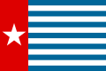
 West Papuan separatists raising the Morning-Star flag in the jungles of Papua, 1971 (from Western New Guinea)
 -
-
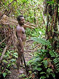
Korowai tribesman (from New Guinea)
-
 Kerepunu women at the marketplace of Kalo, British New Guinea, 1885 (from History of Papua New Guinea)
 -
 Topographical map of New Guinea (from New Guinea)
 -
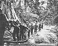
 Australian patrol officer in 1964 (from History of Papua New Guinea)
 -
New Guinea from 1884 to 1919. Germany and Britain controlled the eastern half of New Guinea. (from History of Papua New Guinea)
-
 Rp 0.12 Indonesian stamp of 1963. (from Western New Guinea)
 -
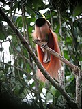
 The king bird-of-paradise is one of over 300 bird species on the peninsula. (from Western New Guinea)
 -
 Flag under German control of New Guinea. (from History of Papua New Guinea)
 -
 A typical map from the Golden Age of Netherlandish cartography. Australasia during the Golden Age of Dutch exploration and discovery (ca. 1590s–1720s): including Nova Guinea (New Guinea), Nova Hollandia (mainland Australia), Van Diemen's Land (Tasmania), and Nova Zeelandia (New Zealand). (from History of Papua New Guinea)
 -
A 1644 map of New Guinea and the surrounding area (from New Guinea)
-
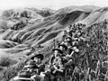 Australian soldiers resting in the Finisterre Ranges of New Guinea while en route to the front line (from New Guinea)
 -
Dutch expeditions in Netherlands New Guinea 1907–1915. (from Western New Guinea)


.png)


.jpg)


.svg)


.jpg)
.jpg)


,_Pairi_daiza_2.jpg)


![Image 59M.S. Rumagesan, Silas Papare, N.L.Suwages, Soegoro Atmoprasodjo [id], and A.H. Nasution in Putra-putra Irian Barat ('Sons of Irian Barat') Conference in Cibogo Bogor, 14–15 April 1961 (from Western New Guinea)](/wiki/File:MS_Rumagesan,_Silas_Papare,_NL_Suwages,_Sugoro,_dan_AH_Nasution_berbincang-bincang,_Konferensi_Cibogo.jpg)
.jpg)


Related portals
WikiProjects
General topics
Categories

Associated Wikimedia
The following Wikimedia Foundation sister projects provide more on this subject:
-
 Commons
Free media repository -
 Wikibooks
Free textbooks and manuals -
 Wikidata
Free knowledge base -
 Wikinews
Free-content news -
 Wikiquote
Collection of quotations -
 Wikisource
Free-content library -
 Wikiversity
Free learning tools -
 Wiktionary
Dictionary and thesaurus
External media

More portals


