Portal:Nepal
स्वागतम् / Welcome to the Nepal Portal
  Budhanilkantha Temple in Budhanilkantha, Nepal
 .svg) Nepal, officially the Federal Democratic Republic of Nepal, is a landlocked country in South Asia. It is mainly situated in the Himalayas, but also includes parts of the Indo-Gangetic Plain. It borders the Tibet Autonomous Region of China to the north, and India to the south, east, and west, while it is narrowly separated from Bangladesh by the Siliguri Corridor, and from Bhutan by the Indian state of Sikkim. Nepal has a diverse geography, including fertile plains, subalpine forested hills, and eight of the world's ten highest mountains, including Mount Everest, the highest point above mean sea level on Earth. Kathmandu is the nation's capital and its largest city. Nepal is a multi-ethnic, multi-lingual, multi-religious, and multi-cultural state, with Nepali as the official language. The name "Nepal" is first recorded in texts from the Vedic period of the Indian subcontinent, the era in ancient Nepal when Hinduism was founded, the predominant religion of the country. In the middle of the first millennium BC, Gautama Buddha, the founder of Buddhism, was born in Lumbini in southern Nepal. Parts of northern Nepal were intertwined with the culture of Tibet. The centrally located Kathmandu Valley is intertwined with the culture of Indo-Aryans, and was the seat of the prosperous Newar confederacy known as Nepal Mandala. The Himalayan branch of the ancient Silk Road was dominated by the valley's traders. The cosmopolitan region developed distinct traditional art and architecture. By the 18th century, the Gorkha Kingdom achieved the unification of Nepal. The Shah dynasty established the Kingdom of Nepal and later formed an alliance with the British Empire, under its Rana dynasty of premiers. The country was never colonised but served as a buffer state between Imperial China and British India. Parliamentary democracy was introduced in 1951 but was twice suspended by Nepalese monarchs, in 1960 and 2005. The Nepalese Civil War in the 1990s and early 2000s resulted in the establishment of a secular republic in 2008, ending the world's last Hindu monarchy. The Constitution of Nepal, adopted in 2015, affirms the country as a federal parliamentary republic divided into seven provinces. In September 2025, protests against a social media ban and economic inequality caused riots, resulting in casualties and resignation of the prime minister. Nepal's foreign policy focuses on neutrality, sovereignty, and multilateral cooperation. Nepal was admitted to the United Nations in 1955, and friendship treaties were signed with India in 1950 and China in 1960. Nepal hosts the permanent secretariat of the South Asian Association for Regional Cooperation (SAARC), of which it is a founding member. Nepal is also a member of the Non-Aligned Movement and the Bay of Bengal Initiative. Nepal's foreign relations also emphasise development assistance, trade partnerships, and promoting peace and stability in South Asia. (Full article...) More Did you know (auto generated)
Selected article - The Fifth Deuba cabinet was the Government of Nepal from 13 July 2021 to 26 December 2022. It was formed after Sher Bahadur Deuba was appointed as the new prime minister of Nepal by president Bidya Devi Bhandari following an order from the Supreme Court, which declared the dissolution of the House of Representatives on the recommendation of former prime minister KP Sharma Oli to be unlawful. The fifth Deuba cabinet was replaced by the Dahal cabinet, 2022 on 26 December 2022, when Pushpa Kamal Dahal's CPN (Maoist Centre) broke away from the electoral alliance with Nepali Congress and joined hands with other opposition parties to form a government in the aftermath of the 2022 general election. The cabinet consisted of an alliance of political parties formed in opposition of former prime minister Oli's dissolution of the House of Representatives. It consisted of Nepali Congress, the CPN (Maoist Centre), CPN (Unified Socialist) and People's Socialist Party, Nepal during formation. The Loktantrik Samajbadi Party, Nepal and Rastriya Janamorcha provides confidence and support to the government. (Full article...)
| |||||||||||||||||||||||||||||||||||||||||||||||||||||||||||||||||||||||||||||||||||||||||||||||||||||||||||||||||||||||||||||||||||||||||||||||||||||||||||||||||||||||||||||||||||||||||||||||||||||||||||||||||||||||||||||||||||||||||||||||||||||||||||||||||||||||||||||||||||||||||||||||||||||||||||||||||||||||||||||||||||
_Flanked_by_Shiva_(left)_and_Ganesha_(right).jpg)
List of Good articles
|
|---|
Selected picture -

The Ganges, is a trans-boundary river of Asia which flows through India and Bangladesh. The 2,525 km (1,569 mi) river rises in the western Himalayas in the Indian state of Uttarakhand, and flows south and east through the Gangetic Plain of North India into Bangladesh, where it empties into the Bay of Bengal. It is the third largest river by discharge.
Categories

Selected biography -

Aniko, Anige or Araniko (Nepali: अरनिको, Chinese: 阿尼哥; 1245–1306) was one of the key figures in the arts of Nepal and the Yuan dynasty of China, and the artistic exchanges in these areas. He was born in Kathmandu Valley during the reign of Abhaya Malla. He is known for building the White Stupa at the Miaoying Temple in Beijing. During the reign of Jayabhimadeva, he was sent on a project to build a golden stupa in Tibet, where he also initiated into monkhood. From Tibet, he was sent further to northern China to work in the court of the emperor Kublai Khan, the founder of the Yuan dynasty, where he brought the trans-Himalayan artistic tradition to China. Araniko led a team of 80 artists to China proper and Tibet to make a number of pagoda-style buildings. In his later life, he renounced monkhood and started a family.
To some confusion in translation, his name is variously written as Arniko or Araniko in old texts. A mistake made by Baburam Acharya ascribed his Sanskrit name as Balabahu. However, later he contends that Aniko might possibly be the Chinese pronunciation for the Sanskrit name Aneka. It is also plausible that his name could mean AA Ni Ka, meaning "respectable brother from Nepal". (Full article...)
Selected fare or cuisine -

Chunlā (Newar: चुंला, "ground meat") is a traditional meat dish of the Kathmandu Valley in Nepal. It is meat finely chopped by a chopping knife or meat grinder. Chunlā is a popular dish in Newar cuisine and is similar to Qeema found in other parts of South Asia. (Full article...)
List of fare/cuisine articles
|
|---|
Did you know -
- ... that Binod Chaudhary is the first Nepali to be listed on Forbes's billionaire list?
- ... that Nepal declared a national day of mourning after the 2019 Taplejung helicopter crash?
Wiki Loves Nepal
  
|
Wiki Loves Earth is an international photographic competition to promote natural heritage sites around the World through Wikimedia projects (mainly Wikipedia and Wikimedia Commons).
- 2018 • 2017 • 2016 • 2015 • 2014 • More information • Main category page

Wiki Loves Monuments is an international photographic competition to promote cultural monuments around the World through Wikimedia projects (mainly Wikipedia and Wikimedia Commons.
- 2017 • 2016 • 2015 • 2014 • 2013 • More information • Main category page
Provinces

General images -
The following are images from various Nepal-related articles on Wikipedia.
-
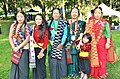 Women in cultural costume at Ubhauli Kirati festival 2017 at Gough Whitlam Park, Earlwood (from Culture of Nepal)
 -
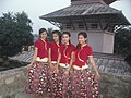 Nepali traditional Pahadi dress used for dance (from Culture of Nepal)
 -
 A 1905 painting of Nepalese woman (from Culture of Nepal)
 -
 The old king's palace on a hill in Gorkha (from History of Nepal)
 -
 Statue of the Bodhisattva Avalokiteshvara, gilded bronze, Nepal, 16th century CE (from Culture of Nepal)
 -
 "Nēpāla" in the late Brahmi script, in the Allahabad Pillar inscription of Samudragupta (350-375 CE). (from History of Nepal)
 -
 Nepali Pahadi Hindu marriage at Narayangadh, Chitawan (from Culture of Nepal)
 -
 Procession of Nepali Hindu Wedding (from Culture of Nepal)
 -

-
 A Buddhist monastery in southern Nepal. (from Culture of Nepal)
 -
 Costumed Hindu girls of Kathmandu during festival time in Nepal (from Culture of Nepal)
 -
 Procession of Nepali Pahadi Hindu Wedding (from Culture of Nepal)
 -
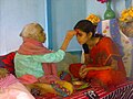
 Senior offering Dashain Tika on great Nepali Hindu festival at a traditional home. (from Culture of Nepal)
 -
 A family in a Maoist-controlled valley, 2005 (from History of Nepal)
 -
 Mohar of king Prithvi Narayan Shah dated Saka Era 1685 (CE 1763) (from History of Nepal)
 -
 Ascension of King Gyanendra, 2001 (from History of Nepal)
 -
 Nepali Pahadi groom (from Culture of Nepal)
 -
 Senior offering Dashain Tika to junior (from Culture of Nepal)
 -
 Procession of Nepali Hindu Wedding; Groom being carried by a bride brother or relatives (from Culture of Nepal)


.jpg)


.jpg)


.jpg)
Topics
| Forts | ||
|---|---|---|
| Religious sites | ||
| Other sites | ||
| World Heritage Sites | ||
|---|---|---|
| Palaces | ||
| Religious sites | ||
| Municipal wise sites | ||
| Kathmandu Metropolis Area sites | ||
| Other sites | ||
| Forts | ||
|---|---|---|
| Religious sites | ||
| Other sites | ||
| Sino-Tibetan (Trans-Himalayan) |
| ||||||||
|---|---|---|---|---|---|---|---|---|---|
| Indo-Aryan |
| ||||||||
| Indo-Aryan of a distinct origin | |||||||||
| Other peoples (M, D, i) of Indus-Ganga |
| ||||||||
| Other basis |
| ||||||||
| Immigrants | |||||||||
| Africa | |
|---|---|
| Americas | |
| Asia | |
| Europe | |
| Oceania | |
| International organizations | |
| Treaties | |
| Related topics | |
| Existing |
| |
|---|---|---|
| Expressway | ||
| Under construction |
| |
| Feeder roads (FR) |
| |
Hydrography of Nepal | ||||||||||||
|---|---|---|---|---|---|---|---|---|---|---|---|---|
| Rivers |
| |||||||||||
| Lakes | ||||||||||||
| Glaciers | ||||||||||||
| Icefalls | ||||||||||||
| Dams, barrages | ||||||||||||
| Related topics | ||||||||||||
| Official language | |||||||||||||||||||
|---|---|---|---|---|---|---|---|---|---|---|---|---|---|---|---|---|---|---|---|
| Indigenous languages |
| ||||||||||||||||||
| Lists by Province | ||
|---|---|---|
| Lists by former Zones | ||
| Africa | |||||||||
|---|---|---|---|---|---|---|---|---|---|
| Asia |
| ||||||||
| Europe | |||||||||
| North America | |||||||||
| Oceania | |||||||||
| National teams |
| ||||||||
|---|---|---|---|---|---|---|---|---|---|
| Domestic Leagues |
| ||||||||
| Cup competitions |
| ||||||||
| Continental club competitions |
| ||||||||
| Regional club competitions |
| ||||||||
| Defunct competitions |
| ||||||||
| Province Associations |
| ||||||||
| National parks | ||
|---|---|---|
| Wildlife reserves | ||
| Conservation areas | ||
| Hunting reserves | ||
| Ramsar sites | ||
Socio-economic issues in Nepal | ||
|---|---|---|
| Economy | ||
| Education | ||
| Environmental issues | ||
| Family | ||
| Children | ||
| Women | ||
| Caste system | ||
| Crime | ||
| Health | ||
| Media | ||
| Other | ||
| Buddhist monasteries in Nepal | ||
|---|---|---|
| Principal temples & pilgrimage sites | ||
| Newar Buddhist temples |
| |
| Vajrayogini temples |
| |
| Theravada Buddhist temples | ||
| Padmasambhava temples & caves |
| |
| Himalayan Buddhist temples | ||
| Tibetan temples | ||
| Cultural | ||
|---|---|---|
| Natural | ||
| 20th century |
| |
|---|---|---|
| 21st century | ||
Related portals
Indian Subcontinent
Other countries
Recognized content
.jpg)


_(restoration).jpg)


_4.jpg)
_(restoration).jpg)


,_male,_Gokarna.jpg)


.jpg)
.jpg)

Associated Wikimedia
The following Wikimedia Foundation sister projects provide more on this subject:
-
 Commons
Free media repository -
 Wikibooks
Free textbooks and manuals -
 Wikidata
Free knowledge base -
 Wikinews
Free-content news -
 Wikiquote
Collection of quotations -
 Wikisource
Free-content library -
 Wikiversity
Free learning tools -
 Wikivoyage
Free travel guide -
 Wiktionary
Dictionary and thesaurus


