Mount Sacagawea
| Mount Sacagawea | |
|---|---|
 Mount Sacagawea from Sacagawea Glacier | |
| Highest point | |
| Elevation | 13,575 ft (4,138 m)[1] |
| Prominence | 409 ft (125 m)[1] |
| Listing | Mountains of Wyoming |
| Coordinates | 43°08′12″N 109°37′30″W / 43.13667°N 109.62500°W[2] |
| Geography | |
 Mount Sacagawea Location in Wyoming  Mount Sacagawea Location in the United States | |
| Location | Fremont / Sublette counties, Wyoming, U.S. |
| Parent range | Wind River Range |
| Topo map | USGS Fremont Peak North (WY) |
| Geology | |
| Rock type | Migmatite[3] |
| Climbing | |
| First ascent | 1926 Albert Ellingwood, Eleanor Davis, Stephen Hart, Marion Warner[1] |
Mount Sacagawea (13,575 ft (4,138 m)) is the eighth-highest peak in the U.S. state of Wyoming and the seventh-highest in the Wind River Range.[4][5] It was named after Sacagawea, the young Lemhi Shoshone woman who accompanied the Lewis and Clark Expedition as an interpreter and guide. The Upper Fremont Glacier is located southeast and the Sacagawea Glacier is northeast of the mountain.[6] Straddling the Continental Divide, Mount Sacagawea is one mile (1.6 km) northwest of Fremont Peak.
Gallery
[edit]-
 Southwest aspect
 -
 Mount Sacagawea (left) and Fremont Peak (right of center)
 -
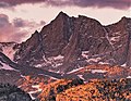 Southwest aspect at sunset


References
[edit]- ^ a b c "Mount Sacagawea, Wyoming". Peakbagger.com. Retrieved May 24, 2013.
- ^ "Mount Sacagawea". Geographic Names Information System. United States Geological Survey, United States Department of the Interior. Retrieved May 24, 2013.
- ^ Joe Kelsey, 2013, Climbing and Hiking in the Wind River Mountains, Falcon Guides, ISBN 9781493001354, page 33.
- ^ "Wind River Range". Peakbagger.com. Retrieved May 24, 2013.
- ^ "Wyoming 13,000-foot Peaks". Peakbagger.com. Retrieved May 24, 2013.
- ^ Fremont Peak North, WY (Map). TopoQwest (United States Geological Survey Maps). Retrieved May 24, 2013.
External links
[edit]Wikimedia Commons has media related to Wind River Range.
- General Information on the Wind River Range Archived 2011-04-14 at the Wayback Machine
- Climbing the Wind River Range (more)
- Glaciers in the Wind River Range
- Shoshone National Forest Federal website
- Continental Divide Trail information
This article about a location in Wyoming is a stub. You can help Wikipedia by expanding it. |