Morpará
Morpará
Município de Morpará | |
|---|---|
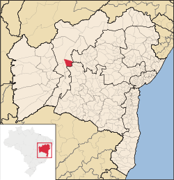
 Location of Morpará in Bahia | |
| Coordinates: 11°33′32″S 43°16′51″W / 11.55889°S 43.28083°W | |
| Country | |
| Region | Northeast |
| State | |
| Founded | 1812 |
| Government | |
| • Mayor | Edinalva Pereira de Almeida (Nalva) |
| Area | |
• Total | 2.090926 km2 (0.807311 sq mi) |
| Population (2020 [1]) | |
• Total | 8,497 |
| • Density | 4,066/km2 (10,530/sq mi) |
| Demonym | Morparaense |
| Time zone | UTC−3 (BRT) |
| Website | morpara |
Morpará is a municipality in the state of Bahia in the North-East region of Brazil. Morpará covers 2.090926 km2 (0.807311 sq mi), and has a population of 8,497 with a population density of 1.28 inhabitants per square kilometer.[2]
History
[edit]Historically, Morpará developed as a small rural settlement in the interior of Bahia, and over time became a local center for agriculture and livestock.[3] Its economy is primarily based on farming, cattle raising, and small-scale commerce that serves the surrounding rural communities.[4] Despite its small size, the town has basic educational and healthcare facilities and functions as an important support hub for nearby villages.[5][6]
See also
[edit]References
[edit]- ^ IBGE 2020
- ^ "Morpará" (in Portuguese). Brasília, Brazil: Instituto Brasileiro de Geografia e Estatística. 2015. Retrieved 2015-08-14.
- ^ "Morpará — Cidades e Estados". Instituto Brasileiro de Geografia e Estatística (IBGE). Retrieved 15 September 2025.
- ^ "Perfil dos Municípios Brasileiros". Instituto Brasileiro de Geografia e Estatística (IBGE). Retrieved 15 September 2025.
- ^ "Rede de Saúde da Bahia". Secretaria de Saúde do Estado da Bahia (SESAB). Retrieved 15 September 2025.
- ^ "Escolas no Município de Morpará". Secretaria de Educação do Estado da Bahia (SEC-BA). Retrieved 15 September 2025.


