Mülheim
Mülheim an der Ruhr | |
|---|---|
 View of the city centre | |
 Flag Coat of arms | |
Location of Mülheim an der Ruhr
within North Rhine-Westphalia
| |
 | |
| Location of Mülheim an der Ruhr | |
 Mülheim an der Ruhr  Mülheim an der Ruhr | |
| Coordinates: 51°25′39″N 06°52′57″E / 51.42750°N 6.88250°E | |
| Country | Germany |
| State | North Rhine-Westphalia |
| Admin. region | Düsseldorf |
| District | Urban district |
| Subdivisions | 3 districts, 9 boroughs |
| Government | |
| • Lord mayor (2020–25) | Marc Buchholz[1] (CDU) |
| Area | |
• Total | 91.28 km2 (35.24 sq mi) |
| Highest elevation | 153 m (502 ft) |
| Lowest elevation | 26 m (85 ft) |
| Population (2023-12-31)[2] | |
• Total | 173,255 |
| • Density | 1,898/km2 (4,916/sq mi) |
| Time zone | UTC+01:00 (CET) |
| • Summer (DST) | UTC+02:00 (CEST) |
| Postal codes | 45468–45481 |
| Dialling codes | 0208, 02054 |
| Vehicle registration | MH |
| Website | www.muelheim-ruhr.de |

Mülheim, officially Mülheim an der Ruhr (German pronunciation: [ˈmyːlhaɪm ʔan deːɐ̯ ˈʁuːɐ̯] ⓘ, lit. 'Mülheim on the Ruhr'; Low German: Mölm; Kölsch: Müllem) and also described as "City on the River", is a city in North Rhine-Westphalia in western Germany. It is located in the Ruhr Area between Duisburg, Essen, Oberhausen and Ratingen. It is home to many companies, and two Max Planck Institutes.
Mülheim an der Ruhr was granted city rights in 1808, and a century later its population surpassed 100,000, officially making it a major city.”
Geography
[edit]Mülheim an der Ruhr is located to the southwest of Essen in the Ruhr valley.[3] The city consists of 19 districts, 14 of which are located on the right bank of the Ruhr and 5 on the left bank.
| Right bank of the Ruhr | Population |
|---|---|
| Altstadt | 24000 |
| Dümpten | 18800 |
| Styrum | 16200 |
| Eppinghofen¹ | 12500 |
| Mellinghofen¹ | 11000 |
| Holthausen | 10800 |
| Heißen | 10000 |
| Heimaterde² | 6300 |
| Winkhausen | 5000 |
| Raadt | 1700 |
| Menden | 1200 |
| Ickten | 200 |
| Left bank of the Ruhr | Population |
| Saarn | 20500 |
| Speldorf | 18900 |
| Broich | 14200 |
| Selbeck | 1800 |
| Mintard | 700 |
¹ Eppinghofen and Mellinghofen are part of the so-called northern city centre (referred to as Altstadt II).
² The old name for Heimaterde in the land register is Fulerum[4].
Figures are estimates based on statistical data from 2025[5].
The city is divided into three administrative districts (Bezirke), six sub-areas (Teilräume) for planning purposes, and nine (official) districts and 28 statistical districts[6]. There are 27 electoral districts for local elections.

Geology
[edit]The northern foothills of the Rhenish Massif are characterised by the distinctive rock formation of the bare mountain slopes through which run coal-bearing layers which formed during the carboniferous period. Here the Ruhr cuts more than 50 meters deep into this Mittelgebirge. This natural erosion partly uncovered these mineable black coal deposits, which enabled their exploration and extraction using adits. However, the coal-rich layers became ever deeper as one progressed northward, which required setting up mines to extract the black coal. In contrast, the broad bayou (dead arm of a river) of Styrum borough is characteristic of the features of the Lower Rhine Plain.[7]
| Rank | Nationality | Population (31.12.2022) |
|---|---|---|
| 1 | 4,807 | |
| 2 | 2,910 | |
| 3 | 1,594 | |
| 4 | 1,423 | |
| 5 | 1,357 | |
| 6 | 1,306 | |
| 7 | 1,243 | |
| 8 | 1,149 | |
| 9 | 1,017 | |
| 10 | 964 |
History
[edit]This section needs expansion. You can help by adding to it. (April 2025) |
Mülheim was chartered in 1808. Between 1878 and 1929, Mülheim absorbed its neighboring towns, including Broich and Heissen.[8] Later, during World War II, forced laborers of the 3rd SS construction brigade were dispatched in the town by the Nazis in 1943.[9]
Transport
[edit]The U18 metro line connects the city with Essen.[10]
The nearest airport is Düsseldorf Airport, located 30 km (19 mi) south west of Mülheim.
Politics
[edit]Mayor
[edit]The current mayor of Mülheim is Marc Buchholz of the Christian Democratic Union (CDU) since 2020. The most recent mayoral election was held on 13 September 2020, with a runoff held on 27 September, and the results were as follows:
| Candidate | Party | First round | Second round | |||
|---|---|---|---|---|---|---|
| Votes | % | Votes | % | |||
| Marc Buchholz | Christian Democratic Union | 16,479 | 25.4 | 27,716 | 56.9 | |
| Monika Griefahn | Social Democratic Party | 16,385 | 25.3 | 20,984 | 43.1 | |
| Wilhelm Steitz | Alliance 90/The Greens | 10,178 | 15.7 | |||
| Horst Bilo | Independent | 5,394 | 8.3 | |||
| Jürgen Abeln | Independent | 4,907 | 7.6 | |||
| Andreas Brings | Die PARTEI | 3,940 | 6.1 | |||
| Alexander von Wrese | Alternative for Germany | 3,920 | 6.0 | |||
| Amrei Debatin | Free Democratic Party | 1,853 | 2.9 | |||
| Jochen Dirk Hartmann | Independent | 945 | 1.5 | |||
| Martin Ulrich Fritz | Civic Awakening Mülheim | 808 | 1.2 | |||
| Valid votes | 64,809 | 98.7 | 48,700 | 98.6 | ||
| Invalid votes | 879 | 1.3 | 679 | 1.4 | ||
| Total | 65,688 | 100.0 | 49,379 | 100.0 | ||
| Electorate/voter turnout | 130,571 | 50.3 | 130,561 | 37.8 | ||
| Source: State Returning Officer | ||||||
City council
[edit]
The Mülheim city council governs the city alongside the mayor. The most recent city council election was held on 13 September 2020, and the results were as follows:
| Party | Votes | % | +/- | Seats | +/- | |
|---|---|---|---|---|---|---|
| Christian Democratic Union (CDU) | 16,970 | 26.3 | 14 | |||
| Alliance 90/The Greens (Grüne) | 15,097 | 23.4 | 13 | |||
| Social Democratic Party (SPD) | 13,765 | 21.3 | 12 | |||
| Alternative for Germany (AfD) | 4,629 | 7.2 | 4 | |||
| Mülheimer Citizens' Initiative (MBI) | 3,043 | 4.7 | 3 | |||
| Free Democratic Party (FDP) | 3,003 | 4.7 | 3 | ±0 | ||
| Die PARTEI (PARTEI) | 2,866 | 4.4 | New | 2 | New | |
| The Left (Die Linke) | 1,751 | 2.7 | 1 | |||
| We From Mülheim (WIR) | 1,560 | 2.4 | 1 | ±0 | ||
| Civic Awakening Mülheim (BAMH) | 1,173 | 1.8 | New | 1 | New | |
| Alliance for Education (BüfBi) | 424 | 0.7 | 0 | |||
| Independents | 226 | 0.4 | – | 0 | – | |
| Valid votes | 64,507 | 98.3 | ||||
| Invalid votes | 1,144 | 1.7 | ||||
| Total | 65,651 | 100.0 | 54 | ±0 | ||
| Electorate/voter turnout | 130,571 | 50.3 | ||||
| Source: State Returning Officer | ||||||
Education and research
[edit]Mülheim is home to two Max Planck Institutes, a university campus, and various other educational and scientific institutions.
- Max Planck Institute for Coal Research
- Max Planck Institute for Chemical Energy Conversion
- Ruhr West University of Applied Sciences, main campus
- IWW Water Centre, water research institute of the University of Duisburg-Essen
- 39 Schools, among them 22 primary schools, 12 general secondary schools, 2 vocational schools, 1 Waldorf school, and 2 special schools
Economy
[edit]Mülheim an der Ruhr has a longstanding industrial heritage as part of the Ruhrgebiet, historically focused on coal mining, steel, and chemicals. While heavy industry has declined, the city has shifted towards logistics, retail, scientific research, and high-value services.
Mülheim has positioned itself as a logistics and services hub within North Rhine-Westphalia, supported by its proximity to Düsseldorf, Essen, and the Rhine-Ruhr transport network. The local economy includes strong retail and food distribution sectors, along with growing activity in energy and environmental sciences, partly driven by the presence of research institutions such as the Max Planck Institutes and Ruhr West University of Applied Sciences.
Companies
[edit]- Siemens Energy (founded 2020), an energy technology company, is the largest employer in Mülheim
- Aldi Süd (founded 1946, split in two parts in 1960, renamed to Aldi Süd in 1962), a discount supermarket chain, has its corporate headquarters in Mülheim
- PVS rhein-ruhr (founded in 1927) handles billing for the healthcare sector[11]
- Europipe GmbH (founded 1991), Europipe produces large seamless pipes for oil and gas pipelines, including Nord Stream
- At ThyssenKrupp Presta, steering systems for the automotive industry are assembled
- Harke Group, formerly Syntana (founded 1965), wholesaler for chemicals
Sports clubs
[edit]- 1. FC Mülheim (founded 1923), a football club. The club from the working-class district of Styrum district celebrated its greatest success with promotion to the 2. Bundesliga (Nord) in 1974, where they played for two seasons.
- VfB Speldorf (founded 1919), a football club. The VfB's greatest success was winning the Niederrheinpokal in 2009
- HTC Uhlenhorst Mülheim (founded 1920), a field hockey club
Twin towns – sister cities
[edit]Notable people
[edit]- William Rittenhouse (1644–1708), founder of the first paper mill in North America
- Gerhard Tersteegen (1697–1769), Reformed religious writer
- Carl Arnold Kortum (1745–1824), physician, writer and poet
- August Bungert (1845–1915), opera composer and poet
- Wilibald Nagel (1863–1929), musicologist
- Hugo Stinnes (1870–1924), industrialist and founder of the German People's Party
- Fritz Thyssen (1873–1951), industrialist associated with the Nazi Party
- Carl Otto von Eicken (1873–1960), otorhinolaryngologist
- Heinrich Thyssen (1875–1947), German-Hungarian entrepreneur and art collector
- Arthur Kaufmann (1888–1971), painter
- Walter Hartmann (1891–1977), general of artillery in World War II
- Dagmar Mühlenfeld (born 1951), mayor of Mülheim an der Ruhr
- Otto Pankok (1893–1966), painter, printmaker and sculptor
- Otto Roelen (1897–1993), chemist
- Karl Ziegler (1898–1973), chemist, Nobel Prize winner
- Clärenore Stinnes (1901–1990), car racer, the first person to circumnavigate the world by automobile
- Werner Best (1903–1989), jurist, police chief and Nazi leader
- Carl Balhaus (1905–1968), actor and director
- Ferdinand aus der Fünten (1909–1989), SS-Hauptsturmführer, war criminal
- Fritz Buchloh (1909–1998), footballer
- Günther Smend (1912–1944), officer and a resistance fighter involved in the July 20 Plot to assassinate Adolf Hitler
- Karl Albrecht (1920–2014), entrepreneur
- Theo Albrecht (1922–2010), entrepreneur
- Wilhelm Knabe (1923–2021), ecologist, pacifist, civil servant and politician
- Wim Thoelke (1927–1995), TV entertainer
- Hermann Bottenbruch (1928–2019), mathematician and computer scientist
- Jürgen Sundermann (born 1940), football player and manager
- Hans Walitza (born 1945), football player and manager
- Rudolf Seliger (born 1951), footballer
- Bodo Hombach (born 1952), politician
- Monika Griefahn (born 1954), politician
- Hans-Günter Bruns (born 1954), footballer
- Helge Schneider (born 1955), comedian, musician, author, film and theatre director and actor
- Ralph Morgenstern (born 1956), television presenter and actor
- Albrecht von Croÿ (born 1958), journalist
- Ulla Kock am Brink (born 1961), television presenter
- Hannelore Kraft (born 1961), politician, Minister-President of North Rhine-Westphalia
- Ralf Lübke (born 1965), athlete
- Carolin Emcke (born 1967), journalist
- Willi Landgraf (born 1968), footballer
- Sven Meinhardt (born 1971), field hockey player, Olympic winner
- André Lenz (born 1973), footballer
- Lars Burgsmüller (born 1975), tennis player
- Marion Rodewald (born 1976), field hockey player, Olympic winner
- Kai Gehring (born 1977), politician
- Felix Erdmann (born 1978), rowing cox
- Simone Hanselmann (born 1979), actress
- Salih Altın (born 1987), footballer
- Bobby Gunns (born 1992), professional wrestler
- Jonathan Rommelmann (born 1994), rower, Olympic medalist
- Stephanie Stebich (born 1966), art historian
- Rüdiger Emshoff (born 1960), maxillofacial surgeon and associate professor
- Karl Schmitz-Scholl (1868-1933), businessman
Gallery
[edit]
-
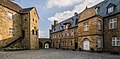 Courtyard of Schloss Broich
 -
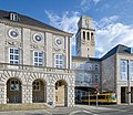 Town Hall
 -
 Mülheim Stadthalle
 -
 View to the street and tram station Aktienstraße
 -
 Friedrichstraße
 -
 Petrikirche
 -
 Highrise buildings in the city centre
 -
 Water feature in MüGa-Park


See also
[edit]References
[edit]- ^ Wahlergebnisse in NRW Kommunalwahlen 2020, Land Nordrhein-Westfalen, accessed 19 June 2021.
- ^ "Alle politisch selbständigen Gemeinden mit ausgewählten Merkmalen am 31.12.2023" (in German). Federal Statistical Office of Germany. 28 October 2024. Retrieved 16 November 2024.
- ^ "Mülheim an der Ruhr". Encyclopaedia Britannica. Retrieved 5 December 2020.
- ^ "Gemarkung Fulerum (Mülheim an der Ruhr) / Nordrhein-Westfalen / Geoindex.io". geoindex.io. Retrieved 2025-11-16.
- ^ "Bevölkerungsbestand". Stadt Mülheim an der Ruhr (in German). 2009-03-24. Retrieved 2025-11-16.
- ^ "Gebietsgliederung / Grenzen". Stadt Mülheim an der Ruhr (in German). 2005-09-09. Retrieved 2025-11-16.
- ^ "Mülheim an der Ruhr official website – Eine kurze Geschichte zur Geologie und zur Geographie des Stadtgebietes".
 (in only German) © 1998–2010 MST Mülheimer Stadtmarketing und Tourismus GmbH. Retrieved 2010-04-19.
- ^ "Mülheim an der Ruhr | Ruhr Valley, Industrial City, Rhine-Ruhr Region | Britannica". www.britannica.com. Retrieved 2025-06-20.
- ^ Megargee, Geoffrey P. (2009). The United States Holocaust Memorial Museum Encyclopedia of Camps and Ghettos 1933–1945. Volume I. Indiana University Press, United States Holocaust Memorial Museum. p. 1385. ISBN 978-0-253-35328-3.
- ^ "Mülheim an der Ruhr". Urban Rail. Retrieved 21 November 2015.
- ^ "Gesellschaft - PVS rhein-ruhr". www.pvs-rr.de. Retrieved 2025-11-16.
- ^ "Städtepartnerschaften" (in German). Mülheim an der Ruhr. Retrieved 2025-09-23.
External links
[edit]- . Encyclopædia Britannica. Vol. 18 (11th ed.). 1911. p. 960.
- Official city homepage

| International | |
|---|---|
| National | |
| Geographic | |
| Other | |