Koniecpol
Koniecpol | |
|---|---|
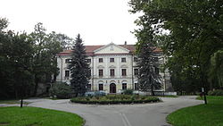
 Potocki Palace | |
| Coordinates: 50°47′N 19°41′E / 50.783°N 19.683°E | |
| Country | |
| Voivodeship | Silesian |
| County | Częstochowa |
| Gmina | Koniecpol |
| Town rights | 1443 |
| Area | |
• Total | 36.52 km2 (14.10 sq mi) |
| Population (2019-06-30[1]) | |
• Total | 5,910 |
| • Density | 160/km2 (420/sq mi) |
| Time zone | UTC+1 (CET) |
| • Summer (DST) | UTC+2 (CEST) |
| Postal code | 42-230 |
| Vehicle registration | SCZ |
| Climate | Dfb |
| Website | www.koniecpol.pl |
Koniecpol [kɔˈɲɛt͡spɔl] is a town in Częstochowa County, Silesian Voivodeship, in southern Poland,[2] with 5,910 inhabitants (2019). It is situated on the Pilica River,[3] in the historic Sieradz Land.
History
[edit]
It was granted town rights by King Władysław III Warneńczyk in 1443.[3] Koniecpol, also known as Nowopole, was a private town, administratively located in the Radomsko County in the Sieradz Voivodeship in the Greater Poland Province of the Kingdom of Poland.[4] It was the seat of the Koniecpolski magnate family, and later it passed to the Czapski and Potocki families.[3] In the 16th century, King Sigismund II Augustus established four annual fairs.[3] In the 17th century, Hetman Stanisław Koniecpolski built the landmark Baroque Holy Trinity church.[3]
Following the joint German-Soviet invasion of Poland, which started World War II in September 1939, it was occupied by Germany until 1945. The occupiers operated a camp for Sinti and Romani people in the town.[5]
Twin towns – sister cities
[edit]See twin towns of Gmina Koniecpol.
Notable residents
[edit]- Henryk Poddębski (1890–1945), Polish photographer and local historian
References
[edit]- ^ "Population. Size and structure and vital statistics in Poland by territorial division in 2019. As of 30th June". Statistics Poland. 2019-10-15. Archived from the original on 2021-04-19. Retrieved 2020-02-14.
- ^ "Główny Urząd Statystyczny" [Central Statistical Office] (in Polish). To search: Select "Miejscowości (SIMC)" tab, select "fragment (min. 3 znaki)" (minimum 3 characters), enter town name in the field below, click "WYSZUKAJ" (Search).
- ^ a b c d e Słownik geograficzny Królestwa Polskiego i innych krajów słowiańskich (in Polish). Vol. IV. Warszawa. 1883. p. 330.
{{cite book}}: CS1 maint: location missing publisher (link) - ^ Atlas historyczny Polski. Województwo sieradzkie i województwo łęczyckie w drugiej połowie XVI wieku. Część I. Mapy, plany (in Polish). Warszawa: Instytut Historii Polskiej Akademii Nauk. 1998. p. 4.
- ^ "Lager für Sinti und Roma Koniecpol". Bundesarchiv.de (in German). Retrieved 16 March 2025.
External links
[edit]- Jewish Community in Koniecpol on Virtual Shtetl


