Haifa el-Atika


Haifa el-Atika (Arabic: حيفا العتيقة; Hebrew: חיפה אל-עתיקה; lit. “Old Haifa”), also known as Medieval Old Haifa, is a neighborhood in the central part of Haifa, Israel, and the location of Haifa prior to its resettlement in 1761 by Zahir al-Umar. It is located south of Bat Galim and east of Kiryat Eliezer, not far from the shore of the Haifa Bay.[1]
It lies at an elevation of up to 50 metres, immediately south of the Rambam Health Care Campus,[2] in an area adjacent to Haifa Bay and bounded by Cheil ha-Yam Street and Derekh Yafo. The neighborhood covers an area of 0.16 square kilometres and has no registered permanent population.[3]
Remnants of the old city walls of Haifa, built in 1761, are located here. Most of the area, however, is used for modern administrative and commercial development.[4]
Gallery
[edit]Contemporary maps showing Haifa's location before 1761
[edit]-
 Sourie Ou Terre Saincte Moderne, Philippe de La Rue, 1657
 -
 Plan du Mont Carmel, Jean Doubdan, 1666 (Acre is #13 on the left of the bay, Haifa is #11 on the right)
 -
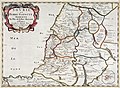
 A Map of the Holy Land and Syria, Richard Pococke, 1745
 -
 Plan De La Rade De St. Jean D'Acre a la Coste de Syrie, Jacques-Nicolas Bellin, published 1764

.jpg)


Later maps showing "Haifa el-Atika"
[edit]-
-
 Plan of Haifa, Frederick Palmer, 1923
 -
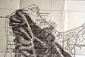
 Survey of Palestine (1:10,000), 1929
 -
 Survey of Palestine (1:20,000), 1932

.jpg)


See also
[edit]References
[edit]- ^ "Geo-Statistical Division of Haifa" (PDF) (in Hebrew and English). haifa.muni.il. Archived from the original (PDF) on 11 July 2011. Retrieved 29 June 2011.
- ^ Safran, Yair (2015). "Haifa al-Jadida: The Surrounding Walls and the City Quarters". Middle Eastern Studies. 51 (3). Taylor & Francis, Ltd.: 452–461. ISSN 0026-3206. JSTOR 24585899. Retrieved 2025-11-30.
- ^ "פרופיל שכונות" (PDF). haifa.muni.il. Archived from the original (PDF) on 19 February 2015. Retrieved 27 June 2011.
- ^ "Sifting through the ruins :: Historic Wadi Salib Under Pressure ::". usa.mediamonitors.net. Retrieved 29 June 2011.