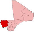
Guidimé
Guidimé | |
|---|---|
| Coordinates: 15°07′05″N 10°34′19″W / 15.118°N 10.572°W | |
| Country | |
| Region | Kayes Region |
| Cercle | Yélimané Cercle |
| Admin HQ (Chef-lieu) | Yélimané |
| Area | |
• Total | 720 km2 (280 sq mi) |
| Population (2009)[2] | |
• Total | 44,019 |
| • Density | 61/km2 (160/sq mi) |
| Time zone | UTC+0 (GMT) |
Guidimé is a rural commune in the Cercle of Yélimané in the Kayes Region of western Mali. The commune includes twelve villages. The administrative center (chef-lieu) is the town of Yélimané. In the 2009 census the commune had a population of 44,019.

Guidimé (sometimes spelled Guidioume or Gidyume) is named after a historical dyamare (chiefdom or confederacy). It became a canton under the French colonial regime, then a commune in the early 1990s, with the traditional elective monarchy transitioning into an elective chef de canton and then mayor of the commune.[3]
References
[edit]- ^ Plan de Sécurité Alimentaire Commune Rurale de Guidimé 2007-2011 (PDF) (in French), Commissariat à la Sécurité Alimentaire, République du Mali, USAID-Mali, 2007, archived from the original (PDF) on 2012-05-13.
- ^ Resultats Provisoires RGPH 2009 (Région de Kayes) (PDF) (in French), République de Mali: Institut National de la Statistique, archived from the original (PDF) on 2012-07-27, retrieved 2011-01-25
{{citation}}: CS1 maint: publisher location (link). - ^ Stéphanie Lima, « L’émergence d’une toponymie plurielle au Mali », L’Espace Politique [En ligne], 5 | 2008-2, mis en ligne le 17 décembre 2008, consulté le 14 septembre 2025. URL : http://journals.openedition.org/espacepolitique/1115 ; DOI : https://doi.org/10.4000/espacepolitique.1115

