Goor
Goor | |
|---|---|
City | |
 Sculpture: the history of Goor | |
 Flag  Coat of arms | |
 Goor Location in province of Overijssel in the Netherlands  Goor Goor (Netherlands) | |
| Coordinates: 52°13′56″N 6°35′12″E / 52.23222°N 6.58667°E | |
| Country | Netherlands |
| Province | Overijssel |
| Municipality | Hof van Twente |
| Area | |
• Total | 19.49 km2 (7.53 sq mi) |
| Elevation | 12 m (39 ft) |
| Population (2021)[1] | |
• Total | 12,155 |
| • Density | 620/km2 (1,600/sq mi) |
| Time zone | UTC+1 (CET) |
| • Summer (DST) | UTC+2 (CEST) |
| Postal code | 7471[1] |
| Dialing code | 0547 |
Goor (pronounced [ɣoːr]) is a city in the Dutch province of Overijssel. It is located about 20 kilometres (12 mi) west of Enschede. Goor received city rights in 1263.
Goor was a separate municipality until 2001, when it became part of Hof van Twente.[3] Goor had a statue of Joan Derk van der Capellen tot den Pol, but it was destroyed in 1787 by royalist Orangists in the defeat of the republican movement.
Jewish community
[edit]While records of individual Jews in Goor date back to the 14th century, the first permanent records of a Jewish community date to the 1600s when residence permits were issued to Jews.[4]
The Joodse begraafplaats ('Jewish cemetery') of Goor on the Borghoek dates to 1720.[5] The Jewish population expanded rapidly in the second half of the 18th century. In 1748, Goor had 13 Jewish residents; that number increased to 238 Jews by 1809.[4] In 1821, the Jews of Goor joined with Jews living in the neighboring towns of Diepenheim and Markelo to build the Ringsynagoge ('regional synagogue').[4]
The Jewish community thrived throughout the 19th and early 20th centuries. Jews contributed to the economic development of Goor and the Twente region. The Jewish Lavino brothers set up a weaving school in Goor.[4] Godfried Salomonson (1838–1911), a Jewish man, established the "Koninklijke Stoomweverij te Nijverdal" ('the Royal Nijverdal Steam Bleaching Works')[a] in 1836 with the express purpose of serving as the center of the Dutch Industrial Revolution.[6] In 1902, a new synagogue on Schoolstraat replaced the old Ringsynagoge.[4]
During the Second World War, nearly the entire Jewish community was openly murdered or sent to concentration camps where they were killed.[7] The synagogue was damaged in air raids, and pulled down after the war.[4] The Jewish cemetery has a monument to the murdered Jews, and was named a national monument in 1970.[4]
Transportation
[edit]Railway Station: Goor
Notable people from Goor
[edit]- Erik Cent (1962), cyclist
- Rutger Kopland (1934–2012), poet
- Tommy Wieringa (born 1964), writer
- Jelle Klaasen (born 1984), darts player
- Renée Luth (born 1979), poet
- Hannie Rouweler (born 1951), poet
- Peter Veenhuizen (born 1964), orchestra conductor and composer
- Hinkelien Schreuder (born 1984), swimmer
Notes
[edit]References
[edit]- ^ a b c "Kerncijfers wijken en buurten 2021". Central Bureau of Statistics. Retrieved 16 March 2022.
Two entries
- ^ "Postcodetool for 7471AA". Actueel Hoogtebestand Nederland (in Dutch). Het Waterschapshuis. Retrieved 16 March 2022.
- ^ Ad van der Meer and Onno Boonstra, Repertorium van Nederlandse gemeenten, KNAW, 2011.
- ^ a b c d e f g "Goor". Jewish Cultural Quarter. Retrieved 12 August 2025.
- ^ Goorsnieuws.nl d.d. 24 september 2009 't is een vreemdeling zeker,.....
- ^ “Godftied Salomomson,” ‘Biografisch Woordenboek van Nederland:1880–2000’, http://resources.huygens.knaw.nl/bwn1880-2000/lemmata/bwn2/salomonson
- ^ Spector, Shmuel; Wigoder, Geoffrey (2001). The Encyclopedia of Jewish Life Before and During the Holocaust: A-J. NYU Press. p. 441. ISBN 978-0-8147-9376-3. Retrieved 12 August 2025.
Further reading
[edit]- "Afgerond onderzoek naar begraafplaatsen in Overijssel" [Completed research on cemeteries in Overijssel]. Het Stenen Archief (in Dutch).
Gallery
[edit]-
 Goor, church: Hofkerk
 -
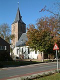
 Goor, Hofkerk in the street
 -
 Goor, windmill: Braakmolen


| International | |
|---|---|
| National | |
| Geographic | |
| Other | |