Gefrees
Gefrees | |
|---|---|
 Gefrees seen from the southeast | |
 Coat of arms | |
Location of Gefrees
within Bayreuth district 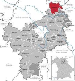 | |
 Location of Gefrees | |
 Gefrees  Gefrees | |
| Coordinates: 50°5′42.50″N 11°44′23.41″E / 50.0951389°N 11.7398361°E | |
| Country | Germany |
| State | Bavaria |
| Admin. region | Oberfranken |
| District | Bayreuth |
| Subdivisions | 44 Ortsteile |
| Government | |
| • Mayor (2020–26) | Oliver Dietel[1] |
| Area | |
• Total | 50.32 km2 (19.43 sq mi) |
| Elevation | 500 m (1,600 ft) |
| Population (2023-12-31)[2] | |
• Total | 4,248 |
| • Density | 84.42/km2 (218.6/sq mi) |
| Time zone | UTC+01:00 (CET) |
| • Summer (DST) | UTC+02:00 (CEST) |
| Postal codes | 95482 |
| Dialling codes | 09254 |
| Vehicle registration | BT |
| Website | www.gefrees.de |
Gefrees (German pronunciation: [ɡəˈfʁeːs] ⓘ) is a town in the district of Bayreuth, in Bavaria, Germany. It is situated in the Fichtel Mountains, 21 km northeast of Bayreuth. It was the site of a battle during the Napoleonic Wars.
References
[edit]- ^ Liste der ersten Bürgermeister/Oberbürgermeister in kreisangehörigen Gemeinden, Bayerisches Landesamt für Statistik, 15 July 2021.
- ^ "Alle politisch selbständigen Gemeinden mit ausgewählten Merkmalen am 31.12.2023" (in German). Federal Statistical Office of Germany. 28 October 2024. Retrieved 16 November 2024.
Towns and municipalities in Bayreuth (district) | ||
|---|---|---|
|  | |
| International | |
|---|---|
| Geographic | |
This Bayreuth district location article is a stub. You can help Wikipedia by expanding it. |