Firuzkuh County
Firuzkuh County
Persian: شهرستان فیروزکوه | |
|---|---|
 Landscape near Tang-e Vashi | |
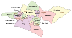
 Location of Firuzkuh County in Tehran province (right, yellow) | |
 Location of Tehran province in Iran | |
| Coordinates: 35°39′N 52°42′E / 35.650°N 52.700°E[1][2] | |
| Country | Iran |
| Province | Tehran |
| Established | 1996[3] |
| Capital | Firuzkuh |
| Districts | Central, Arjomand |
| Area | |
• Total | 2,386 km2 (921 sq mi) |
| Population (2016)[4] | |
• Total | 33,558 |
| • Density | 14/km2 (36/sq mi) |
| Time zone | UTC+3:30 (IRST) |
| Firuzkuh County can be found at GEOnet Names Server, at this link, by opening the Advanced Search box, entering "9206116" in the "Unique Feature Id" form, and clicking on "Search Database". | |
Firuzkuh County (Persian: شهرستان فیروزکوه) is in Tehran province, Iran. Its capital is the city of Firuzkuh.[3]
Demographics
[edit]Population
[edit]At the time of the 2006 National Census, the county's population was 37,416 in 10,414 households.[5] The following census in 2011 counted 38,712 people in 11,828 households.[6] The 2016 census measured the population of the county as 33,558 in 11,700 households.[4]
Administrative divisions
[edit]Firuzkuh County's population history and administrative structure over three consecutive censuses are shown in the following table.
| Administrative division | 2006[5] | 2011[6] | 2016[4] |
|---|---|---|---|
| Central District | 29,036 | 32,359 | 27,056 |
| Hablerud RD | 4,884 | 3,983 | 2,883 |
| Poshtkuh RD | 4,560 | 4,267 | 2,745 |
| Shahrabad RD | 3,785 | 3,738 | 3,975 |
| Firuzkuh (city) | 15,807 | 20,371 | 17,453 |
| Arjomand District | 8,380 | 6,353 | 6,502 |
| Doboluk RD | 3,761 | 3,676 | 3,475 |
| Qazqanchay RD | 2,931 | 1,563 | 1,903 |
| Arjomand (city) | 1,688 | 1,114 | 1,124 |
| Total | 37,416 | 38,712 | 33,558 |
| RD = rural district | |||
Climate
[edit]According to the information of the State Meteorological Organization of Iran, the long-term average annual rainfall of Firuzkuh is around 342.9 mm.[7]
See also
[edit]![]() Media related to Firuzkuh County at Wikimedia Commons
Media related to Firuzkuh County at Wikimedia Commons
References
[edit]- ^ OpenStreetMap contributors (19 September 2024). "Shahrabad RD, Firuzkuh Central District, Firuzkuh County, Tehran Province, Iran" (Map). OpenStreetMap (in Persian). Retrieved 19 September 2024.
- ^ "MM2X+2X5 Mahabad, Tehran Province, Iran" (Map). Google Maps. Retrieved 23 June 2025.
- ^ a b Habibi, Hassan (8 December 1996) [تاریخ تصویب (Approval date) 1375/09/18 (Iranian Jalali calendar)]. ایجاد واحدهای تقسیمات کشوری در تابعیت استان تهران [Creation of units of national divisions in the citizenship of Tehran province]. لام تا کام [Lam ta Kam] (in Persian). وزارت کشور [Ministry of the Interior]. کمیسیون سیاسی دفاعی هیأت دولت [Political Defense Commission of the Government Board]. شناسه [ID] D6DCC6D7-EC25-4CC5-8A80-9DD02D2721C2. شماره دوره [Course number] 75. Archived from the original on 21 June 2025. Retrieved 21 June 2025.
- ^ a b c سرشماري عمومي نفوس و مسكن 1395 : استان تهران [General Population and Housing Census 2016: Tehran Province]. مرکز آمار ایران [Statistical Centre of Iran] (in Persian). Archived from the original (Excel) on 12 December 2021. Retrieved 23 June 2025.
- ^ a b سرشماري عمومي نفوس و مسكن 1385 : استان تهران [General Population and Housing Census 2006: Tehran Province]. مرکز آمار ایران [Statistical Centre of Iran] (in Persian). Archived from the original (Excel) on 20 September 2011. Retrieved 23 June 2025.
- ^ a b سرشماري عمومي نفوس و مسكن 1390 : استان تهران [General Population and Housing Census 2011: Tehran Province]. Iran Data Portal—Syracuse University (in Persian). مرکز آمار ایران [Statistical Centre of Iran]. Archived from the original (Excel) on 20 January 2023. Retrieved 23 June 2025.
- ^ https://tehranmet.ir/uploads/tahghighat/140201.pdf [bare URL PDF]
