Busiki
See also Namutumba District for Busiki District.
Busiki Chiefdom
Eisaaza lya Busiki | |
|---|---|
Traditional Chiefdom | |
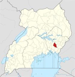
 Location of Namutumba District (historical Busiki) in Uganda | |
| Country | |
| Region | Eastern Region |
| Sub-region | Busoga |
| Founded | c. 1683 |
| Joined British Protectorate | 1896 |
| Government | |
| • Type | Hereditary Chiefdom |
| Elevation | 1,119 m (3,671 ft) |
| Time zone | UTC+3 (EAT) |
| Part of the Busoga Kingdom | |
Busiki is one of the eleven traditional chiefdoms (also referred to as Masaza) of the Busoga Kingdom in Uganda. Its territory primarily corresponds to present-day Namutumba District, historically known as Busiki County, in the Busoga sub-region.
History and establishment
[edit]It was founded around 1683 and became a part of the British protectorate in Busoga in 1896 during when the British were consolidating their control over the various semi-autonomous chiefdoms in the region. Its ruler is known as the Kisiki.[1] Alongside other chiefdoms, Busiki was later federated to form the Kingdom of Busoga in 1906 under colonial administration.
Geography and administrative evolution
[edit]Busiki corresponds closely with Namutumba District, which was part of Iganga District before its establishment in 2005. Namutumba District sometimes still referred to as "Busiki District" is the chief district corresponding to the historical boundaries of the Busiki chiefdom.[2] The locality of Busiki lies just north of Namutumba town, and sits at an elevation of approximately 1,119 metres above sea level.
References
[edit]- ^ "Busoga Kingdom headquarters". Proud Musoga. 2017-06-18. Retrieved 2019-09-13.
- ^ "Schools in Namutumba District – KAWA Uganda". 2019-12-20. Retrieved 2025-08-27.