Budhrail
Budhrail
বুধরাইল | |
|---|---|
Village | |
 | |
| Coordinates: 24°44′35″N 91°35′40″E / 24.74306°N 91.59444°E | |
| Country | Bangladesh |
| Division | Sylhet Division |
| District | Sunamganj District |
| Upazila | Jagannathpur Upazila |
| Union | Syedpur Shaharpara Union |
| Area | |
• Total | 2.85 km2 (1.10 sq mi) |
| Population (2011) | |
• Total | 2,281 |
| Time zone | UTC+6 (BST) |
Budhrail (Bengali: বুধরাইল) is a village located in Syedpur Shaharpara Union of Jagannathpur Upazila, Sunamganj District, in the Sylhet Division of Bangladesh. It lies along the banks of the River Ratna and is part of the historically and culturally rich Sylhet region.
Geography
[edit]Budhrail is situated in the southeastern part of Jagannathpur Upazila. The village covers an area of approximately 2.85 square kilometres. It is bounded by Syedpur to the north, Islampur and Anuchand to the south, Shaharpara and Sunathonpur to the east, and Muradabad and Thegoria to the west. The River Ratna flows along its edge, influencing local agriculture and transportation.
History
[edit]Budhrail forms part of the Syedpur Shaharpara Union Council and shares deep cultural ties with neighbouring villages such as Shaharpara and Syedpur. Like much of the Sylhet region, the area developed as an agrarian settlement near river systems, with farming and trade shaping its local identity.
Demographics
[edit]According to the 2011 Bangladesh census, Budhrail had a population of approximately 2,281 people. The majority of the inhabitants are Bengali Muslims, with a small number of other ethnic groups represented. The literacy rate and living standards have improved over the years, influenced by foreign remittances and access to education.
Economy and livelihood
[edit]The economy of Budhrail is largely based on agriculture, small-scale businesses, and foreign remittances. Many villagers work in farming, fishing, and livestock rearing, which remain the traditional sources of income for most households. Seasonal crops and rice cultivation are the principal agricultural activities, supported by the fertile land along the River Ratna.
In recent decades, foreign remittances have become a vital part of the local economy, particularly from the United Kingdom. A significant number of residents from Budhrail have migrated abroad and settled in cities such as London, Birmingham, Oldham, Derby, and Luton, forming part of the wider British Bangladeshi and Sylheti diaspora. These expatriates regularly send money to their families, contributing substantially to household incomes, education, and community infrastructure projects.
This flow of remittances has transformed the socio-economic structure of Budhrail. Many families have built modern houses, improved access to education, and established small enterprises with funds sent from abroad. However, the village’s growing dependence on remittances also means that its economy can be affected by global economic fluctuations and immigration policies in destination countries.
Education
[edit]Budhrail hosts several educational institutions:
- Budhrail Government Primary School – one of the oldest primary schools in the region, reportedly established in 1795.
- Budhrail Darul Ulum Madrasa – a local Islamic educational institution.
- A government health centre serves the community, providing primary medical care.
Religion and culture
[edit]The majority of the population follows Islam. The village has several mosques, including:
- Budhrail Jame Masjid
- Uttar (North) Budhrail Jame Masjid
Cultural life in Budhrail reflects the traditions of rural Sylhet, with communal gatherings, religious festivals, and strong ties to expatriate family members abroad.
Transport
[edit]Budhrail is accessible by road from Sylhet and Sunamganj, being about one hour’s drive from Sylhet city and roughly ninety minutes from Sunamganj town. Local roads connect the village to nearby unions and marketplaces. River routes are occasionally used for transport and fishing activities.
Development and challenges
[edit]The village faces typical rural development challenges, including road infrastructure, healthcare access, and vulnerability to flooding due to its proximity to haor wetlands. Despite these challenges, remittance income and community initiatives have led to improvements in housing, sanitation, and education.
See also
[edit]References
[edit]- “Budhrail.” Justapedia. Retrieved 2025. [1]
- “Syedpur Shaharpara Union.” Wikipedia. Retrieved 2025. [2]
- “Budhrail (বুধরাইল).” Wikipedia Draft. Retrieved 2025.
- “As a Social Construct: Understanding the Vulnerability of Sunamganj District.” European Scientific Journal. 2023.
External links
[edit]Geography
[edit]Budhrail village is located at 24°44′34.703″N 91°35′41.662″E / 24.74297306°N 91.59490611°E, covering a total area of 1.135 km2. It is surrounded by Syedpur to the north, Islampur and Anuchand to the south, Sunathonpur and Shaharpara to the east, and Muradabad, Syedpur, and Thegoria to the west.[1]
Education
[edit]The oldest primary school in this area is Budhrail Govt. Primary School. It was established in 1795 or earlier.
- Budhrail Govt. Primary School
- Darul Ulum Muradabad and Budhrail Madrasha
Institutions
[edit]Budhrail has a very old health center called Budhrail Govt. Health Center. It was established around 1930–40.
- Budhrail Govt. Health Center
- Budhrail Government Primary School
- Budhrail Jame Mosjid
- Uttar Budhrail Jame Mosjid
Gallery
[edit]-
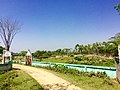 View of Budhrail Koborstan
 -
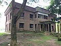 Budhrail Govt. health center
 -
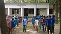 Physical training session of Budhrail primary School
 -
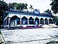
 Budhrail Jame Mosjid
 -
 Uttar Budhrail Jame Mosjid on an evening


See also
[edit]References
[edit]- ^ সৈয়দপুর শাহারপাড়া ইউনিয়ন পরিষদ, জাতীয় তথ্য বাতায়ন - গণপ্রজাতন্ত্রী বাংলাদেশ সরকার - People's Republic of Bangladesh (Bengali). syedpurshaharparaup.sunamganj.gov.bd. Retrieved on 06-02-2017.
Capital: Sunamganj | ||
| Upazilas | ||
| Constituencies | ||
| Attractions and sites | ||
| Rivers | ||
| Inhabited areas | ||
| Educational institutions | ||
| Transport | ||
| History | ||