Beernem
This article needs additional citations for verification. (March 2013) |
Beernem
| |
|---|---|
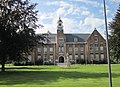
 Bulskampveld Castle | |
 Flag  Coat of arms | |
 Location of Beernem in West Flanders | |
 | |
| Interactive map of Beernem | |
 Beernem Location in Belgium | |
| Coordinates: 51°08′N 03°20′E / 51.133°N 3.333°E | |
| Country | Belgium |
| Community | Flemish Community |
| Region | Flemish Region |
| Province | West Flanders |
| Arrondissement | Bruges |
| Government | |
| • Mayor | Jos Sypré (CD&V) |
| • Governing parties | CD&V, Vooruit, Groen |
| Area | |
• Total | 72.42 km2 (27.96 sq mi) |
| Population (2018-01-01)[1] | |
• Total | 15,687 |
| • Density | 216.6/km2 (561.0/sq mi) |
| Postal codes | 8730 |
| NIS code | 31003 |
| Area codes | 050 |
| Website | www.beernem.be |
Beernem (Dutch pronunciation: [ˈbeːrnəm] ⓘ; West Flemish: Beirnem) is a rural municipality in the Belgian province of West Flanders, located southeast of Bruges. The municipality comprises the towns of Beernem proper, Oedelem and Sint-Joris. On January 1, 2006 Beernem had a total population of 14,642, mostly in Beernem proper and Oedelem. The total area is 71.68 km² which gives a population density of 204 inhabitants per km².
Gallery
[edit]-
 Saint George's church
 -
 Beernem Psychiatrisch Centrum Sint-Amandus
_-_Sint-Joriskerk_1.jpg)

References
[edit]- ^ "Wettelijke Bevolking per gemeente op 1 januari 2018". Statbel. Retrieved 9 March 2019.
External links
[edit] Media related to Beernem at Wikimedia Commons
- (in Dutch) Official website
Places adjacent to Beernem | |
|---|---|
| Bruges |  | |
|---|---|---|
| Diksmuide | ||
| Kortrijk | ||
| Ostend | ||
| Roeselare | ||
| Tielt | ||
| Veurne | ||
| Ypres | ||
| ||
| International | |
|---|---|
| National | |
| Geographic | |
This West Flanders location article is a stub. You can help Wikipedia by expanding it. |