Bazoft District
Bazoft District
Persian: بخش بازفت | |
|---|---|
 View of Bazoft River with the Zardkuh mountain range in the background | |
 Bazoft District | |
| Coordinates: 32°23′N 49°52′E / 32.383°N 49.867°E[1][2] | |
| Country | Iran |
| Province | Chaharmahal and Bakhtiari |
| County | Kuhrang |
| Established | 1995[3] |
| Capital | Bazoft |
| Elevation | 1,520 m (4,990 ft) |
| Population (2016)[4] | |
• Total | 14,742 |
| Time zone | UTC+3:30 (IRST) |
| Area code | +(98) 383 |
| Bazoft District can be found at GEOnet Names Server, at this link, by opening the Advanced Search box, entering "10908563" in the "Unique Feature Id" form, and clicking on "Search Database". | |
Bazoft District (Persian: بخش بازفت) is in Kuhrang County, Chaharmahal and Bakhtiari province, Iran.[5] Its capital is the city of Bazoft.[3][a]
History
[edit]In 2009, Bazoft-e Bala Rural District was created in the district, and Doab Rural District was separated from it in the formation of Doab Samsami District.[7] Two villages were merged to form the new city of Bazoft in 2013.[6]
Demographics
[edit]Ethnicity
[edit]The population is mainly composed of Bakhtiari Lurs from the Haft Lang tribes.[citation needed]
Population
[edit]At the time of the 2006 National Census, the district's population was 14,270 in 2,459 households.[8] The following census in 2011 counted 12,185 people in 2,459 households.[9] The 2016 census measured the population of the district as 14,742 inhabitants living in 3,478 households.[4]
Administrative divisions
[edit]| Administrative Divisions | 2006[8] | 2011[9] | 2016[4] |
|---|---|---|---|
| Bazoft-e Bala RD | 3,305 | 4,144 | |
| Bazoft-e Pain RD[b] | 8,526 | 8,880 | 9,079 |
| Doab RD[c] | 5,744 | ||
| Bazoft (city) | 1,519 | ||
| Total | 14,270 | 12,185 | 14,742 |
| RD = Rural District | |||
Geography
[edit]In the heart of the Zagros mountains, in the foothills of the Zardkuh mountain range, the Bazoft district is located about 180km west of Shahrekord and 200km east of Masjed Soleyman on the Shahrekord-Masjed Soleyman road. The Bazoft river, located near the Zardkuh mountains, is one of the main affluents of the Karun river.
Gallery
[edit]-
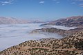 Bazoft valley under a heavy fog
 -
 Zard Kuh mountains from the city of Bazoft
 -
 Bakhtiari nomads settlement
 -
 Goats and sheep in the foothill of Zardkuh
 -
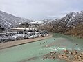 Bazoft river in winter
 -
 Nomadic transhumance in the village of Hossein Abad


See also
[edit]Notes
[edit]- ^ Formerly Chaman Goli[6]
- ^ Formerly Bazoft Rural District[7]
- ^ Transferred to Doab Samsami District[7]
References
[edit]- ^ OpenStreetMap contributors (1 September 2025). "دهستان بازفت بالا, بخش بازفت [Bazoft-e Bala Rural District, Bazoft District], Kuhrang County, Chaharmahal and Bakhtiyari Province, Iran" (Map). OpenStreetMap (in Persian). Retrieved 1 September 2025.
- ^ "9VM8+8MM Shahrak-e Kushka, Chaharmahal and Bakhtiari Province, Iran" (Map). Google Maps. Retrieved 1 September 2025.
- ^ a b Habibi, Hassan (27 September 1995) [تاریخ تصویب (Approval date) 1374/07/05 (Iranian Jalali calendar)]. ایجاد و تأسیس بخش بازفت به مرکزیت روستای چمن گلی در تابعیت شهرستان فارسان در استان چهار محال و بختیاری [Creation and establishment of the Bazoft District centered on the village of Chaman Goli in the jurisdiction of Farsan County in Chaharmahal and Bakhtiari province]. لام تا کام [Lam ta Kam] (in Persian). وزارت کشور [Ministry of the Interior]. کمیسیون سیاسی دفاعی هیأت دولت [Political Defense Commission of the Government Board]. شناسه [ID] 4FDDFF72-BEF5-44BD-9C19-0B886D367EAB. شماره دوره [Course number] 74. Archived from the original on 4 April 2024. Retrieved 1 September 2025.
- ^ a b c سرشماري عمومي نفوس و مسكن 1395 : استان چهارمحال و بختیاری [General Population and Housing Census 2016: Chaharmahal and Bakhtiari Province]. مرکز آمار ایران [Statistical Centre of Iran] (in Persian). Archived from the original (Excel) on 24 May 2019. Retrieved 19 December 2022.
- ^ Habibi, Hassan (18 July 2001) [تاریخ تصویب (Approval date) 1380/04/27 (Iranian Jalali calendar)]. تصویب نامه راجع به ایجاد و تأسیس شهرستان کوهرنگ [Decree on the creation and establishment of Kuhrang County]. لام تا کام [Lam ta Kam] (in Persian). وزارت کشور [Ministry of the Interior]. هیات وزیران [Council of Ministers]. شناسه [ID] 2B9AD588-58F4-4097-97E8-B406F301D97E. شماره دوره [Course number] 80. Archived from the original on 3 December 2023. Retrieved 1 September 2025.
- ^ a b چهار شهر به استان چهارمحال و بختیاری افزوده شد [Four cities added to Chaharmahal and Bakhtiari province]. جام جم آنلاین [Jam Jam Online] (in Persian). 3 August 2013 [۱۲ مرداد ۱۳۹۲ (12 Mordad 1392) (Iranian Jalali calendar)]. کد خبر: ۵۸۵۲۵۲ [News Code: 585252]. Archived from the original on 9 December 2023. Retrieved 1 September 2025.
- ^ a b c Rahimi, Mohammad Reza (27 September 2009) [تاریخ تصویب (Approval date) 1388/07/05 (Iranian Jalali calendar)]. تصویب نامه درخصوص اصلاحات تقسیماتی در استان چهارمحال و بختیاری [Approval regarding divisional reforms in Chaharmahal and Bakhtiari province]. لام تا کام [Lam ta Kam] (in Persian). وزارت کشور [Ministry of the Interior]. کمیسیون سیاسی دفاعی هیأت دولت [Political Defense Commission of the Government Board]. شناسه [ID] 9088EAC9-7887-4887-9D56-17A6A1D03E2C. Archived from the original on 3 December 2023. Retrieved 1 September 2025.
- ^ a b سرشماري عمومي نفوس و مسكن 1385 : استان چهارمحال و بختیاری [General Population and Housing Census 2006: Chaharmahal and Bakhtiari Province]. مرکز آمار ایران [Statistical Centre of Iran] (in Persian). Archived from the original (Excel) on 20 September 2011. Retrieved 25 September 2022.
- ^ a b سرشماري عمومي نفوس و مسكن 1390 : استان چهارمحال و بختیاری [General Population and Housing Census 2011: Chaharmahal and Bakhtiari Province]. Iran Data Portal—Syracuse University (in Persian). مرکز آمار ایران [Statistical Centre of Iran]. Archived from the original (Excel) on 16 January 2023. Retrieved 19 December 2022.
| Capital |  | ||||||||||||||||||||||
|---|---|---|---|---|---|---|---|---|---|---|---|---|---|---|---|---|---|---|---|---|---|---|---|
| Counties and cities |
| ||||||||||||||||||||||
| Landmarks |
| ||||||||||||||||||||||
| populated places | |||||||||||||||||||||||
This Kuhrang County location article is a stub. You can help Wikipedia by expanding it. |